
1902 Map of Raleigh
USGS Topo · Published 1902About this map
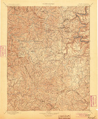
The New River carves a deep path through the coalfields of southern West Virginia in this 1894-95 survey. The river corridor serves as the primary artery for industrial growth, centered on the Chesapeake And Ohio Rr and a string of riverside settlements including Thurmond, Sewell, and Mc Kendree. Beyond the river gorge, the landscape transitions into the high ridges of Guyandot Mountain and Flat Top Mountain, where scattered upland communities like Shady Spring and Oak Hill were beginning to take shape. The map illustrates the early industrial character of the region, where manufacturing sites such as Spangler Factory stood alongside small mountain hamlets and family-named peaks like Lick Knob and Huff Knob. The intricate contour work by Hersey Munroe reveals the challenging topography that dictated the placement of every rail siding and mining camp.
Find a feature on this map
135 named features on this map. Tap any name to fly to it.
Don’t see what you’re looking for? This feature index may not catch every label — zoom into the map to look around manually.
Map Details
Editions of this 1902 Raleigh Map
3 editions found
Other maps of this area

1887 · Pocahontas
USGS Topo · 1:125,000

1887 · Hinton
USGS Topo · 1:125,000

1889 · Nicholas
USGS Topo · 1:125,000

1890 · Dublin
USGS Topo · 1:125,000

1891 · Tazewell
USGS Topo · 1:125,000

1891 · Nicholas
USGS Topo · 1:125,000

1891 · Pocahontas
USGS Topo · 1:125,000

1891 · Dublin
USGS Topo · 1:125,000

1891 · Oceana
USGS Topo · 1:125,000

1891 · Raleigh
USGS Topo · 1:125,000