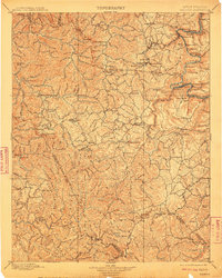
1902 Map of Raleigh
USGS Topo · Published 1910About this map
Coal and commerce drive the landscape along the Chesapeake & Ohio RR at the turn of the century, where the river-level settlements of Thurmond and Quinnimont serve as vital hubs for the surrounding plateaus. The map details a dense network of mining and rail towns like Glenjean, Macdonald, and Mount Hope, which flourished as the New River Gorge and its tributaries were developed for resource extraction. Along the winding course of the New River, numerous small stops such as Beury, Echo, and Fire Creek are positioned between the steep canyon walls and the upland ridges.
Find a feature on this map
174 named features on this map. Tap any name to fly to it.
Don’t see what you’re looking for? This feature index may not catch every label — zoom into the map to look around manually.
Map Details
Editions of this 1902 Raleigh Map
3 editions found

Other maps of this area

1887 · Pocahontas
USGS Topo · 1:125,000

1887 · Hinton
USGS Topo · 1:125,000

1889 · Nicholas
USGS Topo · 1:125,000

1890 · Dublin
USGS Topo · 1:125,000

1891 · Tazewell
USGS Topo · 1:125,000

1891 · Nicholas
USGS Topo · 1:125,000

1891 · Pocahontas
USGS Topo · 1:125,000

1891 · Dublin
USGS Topo · 1:125,000

1891 · Oceana
USGS Topo · 1:125,000

1891 · Raleigh
USGS Topo · 1:125,000