1970s Maps of Barron County, Wisconsin
Explore 19 historic maps of Barron County from the 1970s. These maps offer a rare glimpse into what life looked like during the 1970s — showing old roads, neighborhoods, homes, and landmarks that have changed or disappeared over time.
Whether you're researching your family's past, planning a metal detecting trip, or studying how Barron County's landscape evolved across the 1970s, these high-resolution maps are a powerful tool for exploring the history of this region.
- Focus on a specific era: All maps on this page are from the 1970s, giving you a focused view of this time period.
- See what’s changed: Compare century-old streets, trails, and buildings to today's modern landscape using overlays and satellite layers.
- Research with precision: Use these maps for genealogy, historical research, land use analysis, or educational projects.
- View, download, or print: Maps are fully viewable online in high resolution, and can be downloaded or printed for your own records.
Start exploring Barron County's history through authentic maps from the 1970s. This is your window into the past.
Barron County, WI maps
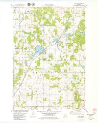
(19)- 1975 Map of Stillwater
 1975 Stillwater1975 Print · USGSThe Twin Cities and the St. Croix Valley are captured in the mid-seventies, showing the urban growth of Minneapolis and St Paul. Researchers can trace old rail corridors of the Northern Pacific RR and locate tribal lands at the Mille Lacs Indian Reservation.2 unique versions available
 - 1975 Map of Connorsville, 1978 Print
 1975 Connorsville1978 Print · USGSDunn and Barron Counties are captured in the mid-seventies, showing a network of rural hamlets and winding waterways. Genealogists can locate family sites like Akers Cem and New Haven Cem or trace the early paths of Sheridan Rd.
 - 1975 Map of New Auburn, 1978 Print
 1975 New Auburn1978 Print · USGSWestern Wisconsin life in the mid-seventies centers on the village of New Auburn and its position along the Chicago and North Western railroad. Researchers can locate family sites at the New Auburn Cem, trace Duncan Creek, or explore the wooded Old Maids Bluff.
 - 1975 Map of Sand Creek, 1978 Print
 1975 Sand Creek1978 Print · USGSNorthwest Wisconsin in the 1970s shows a landscape defined by the winding Red Cedar River and the rural communities of Dunn and Barron Counties. Genealogists and local historians can trace family locations near Sand Creek, Cruikshank, and several early burial grounds including Zion Cem and Springbrook Cem.
 - 1975 Map of Ridgeland NE, 1978 Print
 1975 Ridgeland NE1978 Print · USGSNorthern Dunn County was a landscape of creek valleys and country schools in the mid-seventies. Genealogists and historians can trace family-named sites like Massie Road, old burials at Tollebu Cem, and the path of an Old RR Grade.
 - 1975 Map of Graytown, 1978 Print
 1975 Graytown1978 Print · USGSSmall farming settlements and the headwaters of the Willow River define this western Wisconsin region in the mid-seventies. Genealogists can trace family footprints at Sunnyside Sch, Reeve, and the Old Grade Railroad.
 - 1975 Map of Ridgeland, 1978 Print
 1975 Ridgeland1978 Print · USGSThe rural border of Barron and Dunn Counties is captured here in the mid-seventies, showing the agricultural and water-powered roots of the region. Researchers can trace family sites near Evergreen Cem, the Old RR Grade, or the Harmon Brothers Landing Strip.
 - 1978 Map of Poskin, 1979 Print
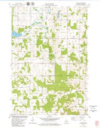
 1978 Poskin1979 Print · USGSBarron County's rural landscape is captured here in the late seventies, centered on the settlement of Poskin. Genealogists and local historians can trace family locations near the SOO LINE rail corridor, Poskin Cem, and the Paul Revere Community Center.
 - 1978 Map of Barron, 1979 Print
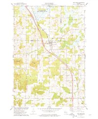
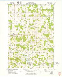
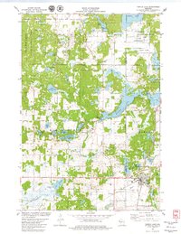
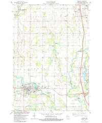 1978 Barron1979 Print · USGSBarron and the surrounding townships are captured in the late seventies, showing a landscape defined by the winding Red Cedar and Yellow Rivers. Researchers can locate the Soo Line rail corridor, the Swede Cem, and the County Museum near the heart of Barron.
 - 1978 Map of Dority Creek, 1979 Print
 1978 Dority Creek1979 Print · USGSBarron County’s agricultural landscape is captured in the late 1970s, showing a transition between working farms and the natural hydrology of the Hay River basin. Genealogists and local historians can trace the Old Railroad Grade and locate ancestral sites at Maple Grove Cem or Glenwood Cem.
 - 1978 Map of Rice Lake South, 1979 Print
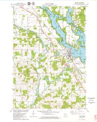
 1978 Rice Lake South1979 Print · USGSBarron County in the late seventies shows a landscape of lakefront growth and rural tradition centered on the Rice Lake corridor. Genealogists and local historians can trace family sites at St Joseph Cemetery or the Pioneer Rest Cemetery, and locate vanished landmarks like the Drive-in Theater.
 - 1978 Map of Chetek, 1979 Print
 1978 Chetek1979 Print · USGSBarron County’s lake country is captured here in the late seventies, showing the intricate intersection of the Chetek River and the Chicago and North Western rail line. Researchers can locate family landmarks like Otterholt Cem and Pittmans Point among the many island-dotted bays.
 - 1978 Map of Clayton, 1979 Print
 1978 Clayton1979 Print · USGSClayton and the surrounding townships in Polk and Barron Counties are captured in the late seventies as the Chicago and North Western railroad still defined the local corridor. Researchers can trace rural lineages through landmarks like West Clayton Cemetery, Moe Church, and Holy Trinity Church.
 - 1978 Map of Moose Ear Lake, 1979 Print
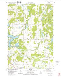 1978 Moose Ear Lake1979 Print · USGSNorthern Wisconsin lake country is captured here in the late seventies, showing the complex shorelines and rural life of the Chetek area. You can trace family history at the Johnson Cem or locate old community landmarks like Bass Lake Ch and the Chicago and North Western rail line.
 - 1978 Map of Strickland, 1979 Print
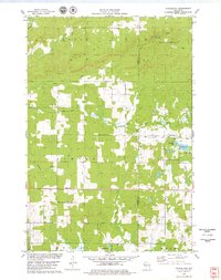 1978 Strickland1979 Print · USGSBarron and Rusk counties were defined by heavy timber and glacial lakes in the late seventies. Family historians can trace the Soo Line rail corridor through old stops at Lehigh and Strickland, or locate family landmarks near Perdziak Lake.
 - 1978 Map of Dallas, 1979 Print
 1978 Dallas1979 Print · USGSIn the late seventies, this portion of Barron County shows a quiet landscape of dairy farms and river bends near Dallas. Genealogists and local historians can trace family plots at Old Hillsdale Cem or follow the path of the Old Railroad Grade.
 - 1978 Map of Arland, 1979 Print
 1978 Arland1979 Print · USGSBarron County farmland and the small crossroads of Arland are mapped here in the late seventies. Family historians can locate numerous rural burial sites like Peace Cem and Sunset Cem, alongside local landmarks like Thompson Park.
 - 1978 Map of Almena, 1979 Print
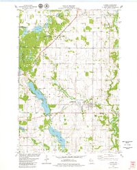 1978 Almena1979 Print · USGSWestern Barron County is shown here in the late seventies, centered on the chain of lakes and wetlands between Almena and Comstock. Local historians can locate specific sites like Lake View Cem, the Chicago and Northwestern tracks, and Loon Lake State Wildlife Area.
 - 1978 Map of Turtle Lake, 1979 Print
 1978 Turtle Lake1979 Print · USGSTurtle Lake at the end of the 1970s shows a classic Wisconsin rail-junction village surrounded by a dense landscape of lakes and wetlands. Researchers can trace the Soo Line rail corridors, the historic Old Mill Pond, and family landmarks like Mt Hope Cem.
End of results
Showing maps 1-19 of 19
Top cities of Barron County
- Rice Lake historical maps
- Barron historical maps
- Cumberland historical maps
- Chetek historical maps
- Cameron historical maps
- Almena historical maps
See more
Frequently asked questions
- What are the different types of historical maps available for Barron County?
- What is the oldest map of Barron County?
- Where can I purchase historical maps of Barron County for my home or office?
- Where can I download high-res historical maps of Barron County?
- Are there historical topographic maps available for Barron County?
- Is there historical aerial imagery available for Barron County?
- Where are historical maps of Barron County sourced from?