1940s Maps of Prairie Farm, Wisconsin
Explore 2 historic maps of Prairie Farm from the 1940s. These maps offer a rare glimpse into what life looked like during the 1940s — showing old roads, neighborhoods, homes, and landmarks that have changed or disappeared over time.
Whether you're researching your family's past, planning a metal detecting trip, or studying how Prairie Farm's landscape evolved across the 1940s, these high-resolution maps are a powerful tool for exploring the history of this region.
- Focus on a specific era: All maps on this page are from the 1940s, giving you a focused view of this time period.
- See what’s changed: Compare century-old streets, trails, and buildings to today's modern landscape using overlays and satellite layers.
- Research with precision: Use these maps for genealogy, historical research, land use analysis, or educational projects.
- View, download, or print: Maps are fully viewable online in high resolution, and can be downloaded or printed for your own records.
Start exploring Prairie Farm's history through authentic maps from the 1940s. This is your window into the past.
Prairie Farm, WI maps
(2)- 1948 Map of Downing, 1970 Print
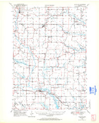
 1948 Downing1970 Print · USGSWestern Wisconsin's agricultural and rail heartland is captured here in the late 1940s, centered on the villages of the Tiffany Creek valley. Genealogists can trace family roots through dozens of rural landmarks like Beaver Valley Sch, Graytown, and Immanuel Ch.
 - 1949 Map of Ridgeland, 1970 Print
 1949 Ridgeland1970 Print · USGSThe rural borderlands of Barron and Dunn counties are captured here in the late 1940s, when small-town rail hubs and country schoolhouses still dotted the landscape. Researchers can trace family roots through numerous sites like Evergreen Cem, Vanceburg, and Parkman Sch.
End of results
Showing maps 1-2 of 2
Top cities near Prairie Farm
- Rice Lake historical maps
- Barron historical maps
- Tainter historical maps
- Cameron historical maps
- Glenwood City historical maps
- Boyceville historical maps
See more
Frequently asked questions
- What are the different types of historical maps available for Prairie Farm?
- What is the oldest map of Prairie Farm?
- Where can I purchase historical maps of Prairie Farm for my home or office?
- Where can I download high-res historical maps of Prairie Farm?
- Are there historical topographic maps available for Prairie Farm?
- Is there historical aerial imagery available for Prairie Farm?
- Where are historical maps of Prairie Farm sourced from?