1970s Maps of Vance Creek, Wisconsin
Explore 5 historic maps of Vance Creek from the 1970s. These maps offer a rare glimpse into what life looked like during the 1970s — showing old roads, neighborhoods, homes, and landmarks that have changed or disappeared over time.
Whether you're researching your family's past, planning a metal detecting trip, or studying how Vance Creek's landscape evolved across the 1970s, these high-resolution maps are a powerful tool for exploring the history of this region.
- Focus on a specific era: All maps on this page are from the 1970s, giving you a focused view of this time period.
- See what’s changed: Compare century-old streets, trails, and buildings to today's modern landscape using overlays and satellite layers.
- Research with precision: Use these maps for genealogy, historical research, land use analysis, or educational projects.
- View, download, or print: Maps are fully viewable online in high resolution, and can be downloaded or printed for your own records.
Start exploring Vance Creek's history through authentic maps from the 1970s. This is your window into the past.
Vance Creek, WI maps
(5)- 1975 Map of Stillwater
 1975 Stillwater1975 Print · USGSThe Twin Cities and the St. Croix Valley are captured in the mid-seventies, showing the urban growth of Minneapolis and St Paul. Researchers can trace old rail corridors of the Northern Pacific RR and locate tribal lands at the Mille Lacs Indian Reservation.2 unique versions available
 - 1975 Map of Connorsville, 1978 Print
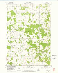
 1975 Connorsville1978 Print · USGSDunn and Barron Counties are captured in the mid-seventies, showing a network of rural hamlets and winding waterways. Genealogists can locate family sites like Akers Cem and New Haven Cem or trace the early paths of Sheridan Rd.
 - 1975 Map of Graytown, 1978 Print
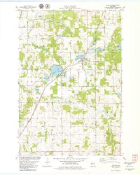
 1975 Graytown1978 Print · USGSSmall farming settlements and the headwaters of the Willow River define this western Wisconsin region in the mid-seventies. Genealogists can trace family footprints at Sunnyside Sch, Reeve, and the Old Grade Railroad.
 - 1978 Map of Clayton, 1979 Print
 1978 Clayton1979 Print · USGSClayton and the surrounding townships in Polk and Barron Counties are captured in the late seventies as the Chicago and North Western railroad still defined the local corridor. Researchers can trace rural lineages through landmarks like West Clayton Cemetery, Moe Church, and Holy Trinity Church.
 - 1978 Map of Arland, 1979 Print
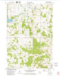 1978 Arland1979 Print · USGSBarron County farmland and the small crossroads of Arland are mapped here in the late seventies. Family historians can locate numerous rural burial sites like Peace Cem and Sunset Cem, alongside local landmarks like Thompson Park.
End of results
Showing maps 1-5 of 5
Top cities near Vance Creek
- Barron historical maps
- Tainter historical maps
- Glenwood City historical maps
- Town of Black Brook historical maps
- Clear Lake historical maps
- Boyceville historical maps
See more
Top neighborhoods of Vance Creek
Frequently asked questions
- What are the different types of historical maps available for Vance Creek?
- What is the oldest map of Vance Creek?
- Where can I purchase historical maps of Vance Creek for my home or office?
- Where can I download high-res historical maps of Vance Creek?
- Are there historical topographic maps available for Vance Creek?
- Is there historical aerial imagery available for Vance Creek?
- Where are historical maps of Vance Creek sourced from?