1940s Maps of Clover, Wisconsin
Explore 8 historic maps of Clover from the 1940s. These maps offer a rare glimpse into what life looked like during the 1940s — showing old roads, neighborhoods, homes, and landmarks that have changed or disappeared over time.
Whether you're researching your family's past, planning a metal detecting trip, or studying how Clover's landscape evolved across the 1940s, these high-resolution maps are a powerful tool for exploring the history of this region.
- Focus on a specific era: All maps on this page are from the 1940s, giving you a focused view of this time period.
- See what’s changed: Compare century-old streets, trails, and buildings to today's modern landscape using overlays and satellite layers.
- Research with precision: Use these maps for genealogy, historical research, land use analysis, or educational projects.
- View, download, or print: Maps are fully viewable online in high resolution, and can be downloaded or printed for your own records.
Start exploring Clover's history through authentic maps from the 1940s. This is your window into the past.
Clover, WI maps
(8)- 1943 Map of Port Wing, 1952 Print
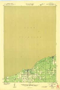
 1943 Port Wing1952 Print · USGSThe southern shore of Lake Superior comes into focus during the early 1940s, highlighting the coastal life and interior woodlands of Bayfield County. Researchers can trace the development of Port Wing and Herbster or locate family sites near Greenwood Cem and the Flag River.
 - 1943 Map of Iron Lake, 1952 Print
 1943 Iron Lake1952 Print · USGSBayfield County at the height of the 1940s reveals a landscape of lakeside settlements and rural school districts centered around Iron River. Genealogists and local researchers can trace early homesteads and landmarks like Hillside Cem, Washington Sch, and the Iron River Fire Tower.
 - 1944 Map of Moquah, 1952 Print
 1944 Moquah1952 Print · USGSBayfield County at the end of the Second World War shows a landscape of timber-town history and rural school districts. Genealogists and historians can trace the foundations of Moquah, locate family-named schoolhouses like Gednota Sch, and follow the long-vanished Old Grade logging routes.2 unique versions available
 - 1944 Map of Cornucopia, 1952 Print
 1944 Cornucopia1952 Print · USGSThe Lake Superior shoreline near Cornucopia is shown here during the 1940s as a hub for coastal settlement and forest access. Genealogists can locate family landmarks like St Anthony Ch, Settlement Sch, and the docks of Cornucopia.
 - 1946 Map of Cornucopia
 1946 Cornucopia1946 Print · USGSThe northern reaches of Bayfield County are captured here in the mid-1940s, highlighting the coastal community of Cornucopia. Researchers can trace old rural landmarks like the Settlement Sch, St Anthony Ch, and the numerous inlets of Bark Bay.
 - 1946 Map of Port Wing
 1946 Port Wing1946 Print · USGSThe Bayfield County coast along Lake Superior is captured in the mid-1940s just as early highway and utility networks were expanding. Researchers can locate family sites near Port Wing and Herbster, or trace old forest trails like T Tr 181L and the Greenwood Cem.
 - 1947 Map of Moquah
 1947 Moquah1947 Print · USGSBayfield County in the late 1940s reveals a landscape of rural schoolhouses and forest management hubs like the Brinks Ranger Sta. Genealogists and historians can trace family locations near Hillsdale Sch, Gednota Sch, and the rail stop at Ino Sta.
 - 1947 Map of Iron Lake
 1947 Iron Lake1947 Print · USGSBayfield County at the end of the 1940s reveals a landscape of lakeside settlements and rural school districts linked by the Northern Pacific line. Researchers can trace local genealogy at Hillside Cem or locate former community sites like Kolin and Miles Sch.
End of results
Showing maps 1-8 of 8
Top cities near Clover
Top neighborhoods of Clover
Frequently asked questions
- What are the different types of historical maps available for Clover?
- What is the oldest map of Clover?
- Where can I purchase historical maps of Clover for my home or office?
- Where can I download high-res historical maps of Clover?
- Are there historical topographic maps available for Clover?
- Is there historical aerial imagery available for Clover?
- Where are historical maps of Clover sourced from?