2020s Maps of Drummond, Wisconsin
Explore 9 historic maps of Drummond from the 2020s. These maps offer a rare glimpse into what life looked like during the 2020s — showing old roads, neighborhoods, homes, and landmarks that have changed or disappeared over time.
Whether you're researching your family's past, planning a metal detecting trip, or studying how Drummond's landscape evolved across the 2020s, these high-resolution maps are a powerful tool for exploring the history of this region.
- Focus on a specific era: All maps on this page are from the 2020s, giving you a focused view of this time period.
- See what’s changed: Compare century-old streets, trails, and buildings to today's modern landscape using overlays and satellite layers.
- Research with precision: Use these maps for genealogy, historical research, land use analysis, or educational projects.
- View, download, or print: Maps are fully viewable online in high resolution, and can be downloaded or printed for your own records.
Start exploring Drummond's history through authentic maps from the 2020s. This is your window into the past.
Drummond, WI maps
(9)- 2022 Map of Drummond NW, 2022 Print
 2022 Drummond NW2022 Print · USGSBayfield County's glacial lake country is preserved here in the early twenty-first century within the Chequamegon National Forest. Trace the winding North Country National Scenic Trl past Wilderness Lake, Trout Lake, and the remote Ducetts Lakes.
 - 2022 Map of Delta, 2022 Print
 2022 Delta2022 Print · USGSBayfield County's lake country is seen here in recent years, dominated by the timberlands of the Chequamegon National Forest. Researchers can locate seasonal properties and shoreline landmarks around Lake Delta, Spirit Lake, and Eagle Lake.
 - 2022 Map of Lake Tahkodah, 2022 Print
 2022 Lake Tahkodah2022 Print · USGSBayfield County's northwoods are captured in this recent survey of the glacial lake country between Cable and Seeley. Outdoor historians and researchers can map the modern trail systems like Esker Trl and locate remote water bodies including Filing Shed Lake and Birch Lake.
 - 2022 Map of Upper Eau Claire Lake, 2022 Print
 2022 Upper Eau Claire Lake2022 Print · USGSNorthern Wisconsin's lake country is captured here in the early twenty-first century, showing the dense woods and water of Bayfield County. Researchers can trace land tracts near Upper Eau Claire Lake or find local landmarks like Eau Claire Lakes Airport and Shunenberg Springs.
 - 2022 Map of Cable, 2022 Print
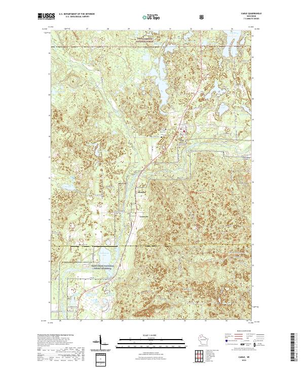 2022 Cable2022 Print · USGSCable and the surrounding northwoods are captured in the early 2020s as a landscape defined by glacial lakes and the winding Namakagon. Researchers can locate Saint Anne Cem, the old sites of Leonards and Radspur, and family-named landmarks like Silverthorn Lake.
 - 2022 Map of Drummond, 2022 Print
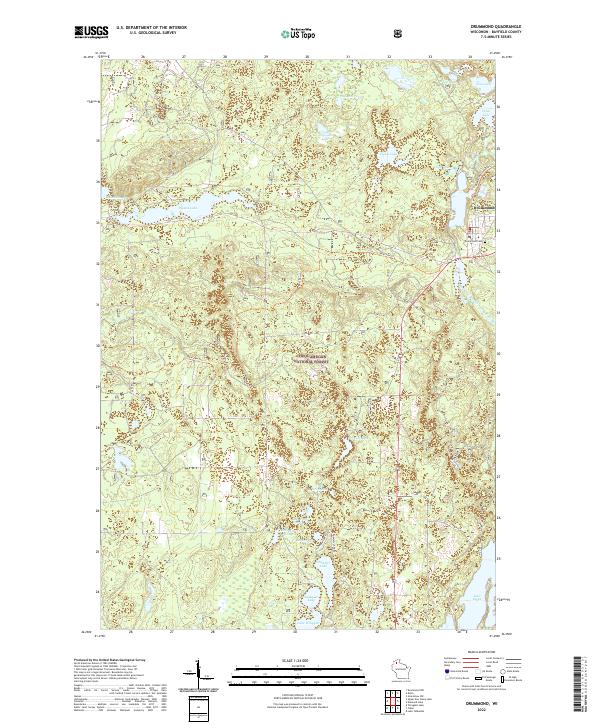 2022 Drummond2022 Print · USGSDrummond and the surrounding Northwoods appear in the early 2020s as a haven of glacial lakes and forest trails. Researchers can locate the Drummond Cem, follow the Bear-Paw Trl, or explore the shores of Pigeon Lake and Lake Owen.
 - 2022 Map of Diamond Lake, 2022 Print
 2022 Diamond Lake2022 Print · USGSThe Northwoods of Bayfield County are captured here in a period of modern forest management and recreation. Map collectors and hikers can trace the North Country National Scenic Trl past remote waters like Pot Lake and Lake Owen.
 - 2022 Map of Grandview NW, 2022 Print
 2022 Grandview NW2022 Print · USGSBayfield County’s forest and lake country is captured here during the early 2020s, showing a landscape defined by water and woods. Researchers can locate the Delta Cem and trace the many forest roads and creeks connecting Sutherland to the Bibon Marsh.
 - 2022 Map of Totagatic Lake, 2022 Print
 2022 Totagatic Lake2022 Print · USGSThe north woods of Bayfield and Sawyer Counties are captured here in the early 2020s, showing a landscape of dense forest and winding river systems. Outdoor enthusiasts and researchers can trace the course of the Totagatic River and find access points via Hills Mills Rd and the Tagalder Trl.
End of results
Showing maps 1-9 of 9
Top cities near Drummond
Top neighborhoods of Drummond
Frequently asked questions
- What are the different types of historical maps available for Drummond?
- What is the oldest map of Drummond?
- Where can I purchase historical maps of Drummond for my home or office?
- Where can I download high-res historical maps of Drummond?
- Are there historical topographic maps available for Drummond?
- Is there historical aerial imagery available for Drummond?
- Where are historical maps of Drummond sourced from?