1990s Maps of Brillion, Wisconsin
Explore 2 historic maps of Brillion from the 1990s. These maps offer a rare glimpse into what life looked like during the 1990s — showing old roads, neighborhoods, homes, and landmarks that have changed or disappeared over time.
Whether you're researching your family's past, planning a metal detecting trip, or studying how Brillion's landscape evolved across the 1990s, these high-resolution maps are a powerful tool for exploring the history of this region.
- Focus on a specific era: All maps on this page are from the 1990s, giving you a focused view of this time period.
- See what’s changed: Compare century-old streets, trails, and buildings to today's modern landscape using overlays and satellite layers.
- Research with precision: Use these maps for genealogy, historical research, land use analysis, or educational projects.
- View, download, or print: Maps are fully viewable online in high resolution, and can be downloaded or printed for your own records.
Start exploring Brillion's history through authentic maps from the 1990s. This is your window into the past.
Brillion, WI maps
(2)- 1992 Map of Hilbert, 1996 Print
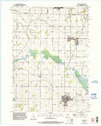 1992 Hilbert1996 Print · USGSCalumet and Brown counties are mapped here in the early 1990s, capturing a landscape of dairy-country road grids and quiet village life. Genealogists can trace family landmarks like Saint Peters Cemetery, the Forest Assembly Ground, and the small settlement of St John.
 - 1992 Map of Brillion, 1996 Print
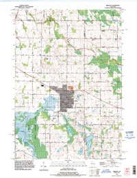 1992 Brillion1996 Print · USGSBrillion and the surrounding dairy country of Calumet County are captured here in the early nineties as the town expanded near the Brillion State Wildlife Area. Local researchers can locate family plots at St Marys Cemetery or trace the old roads like Riets Mills Road and Taus Road.
End of results
Showing maps 1-2 of 2
Top cities near Brillion
- De Pere historical maps
- Kaukauna historical maps
- Little Chute historical maps
- Ledgeview historical maps
- Harrison historical maps
- Kimberly historical maps
See more
Top neighborhoods of Brillion
Frequently asked questions
- What are the different types of historical maps available for Brillion?
- What is the oldest map of Brillion?
- Where can I purchase historical maps of Brillion for my home or office?
- Where can I download high-res historical maps of Brillion?
- Are there historical topographic maps available for Brillion?
- Is there historical aerial imagery available for Brillion?
- Where are historical maps of Brillion sourced from?