1970s Maps of Goetz, Wisconsin
Explore 5 historic maps of Goetz from the 1970s. These maps offer a rare glimpse into what life looked like during the 1970s — showing old roads, neighborhoods, homes, and landmarks that have changed or disappeared over time.
Whether you're researching your family's past, planning a metal detecting trip, or studying how Goetz's landscape evolved across the 1970s, these high-resolution maps are a powerful tool for exploring the history of this region.
- Focus on a specific era: All maps on this page are from the 1970s, giving you a focused view of this time period.
- See what’s changed: Compare century-old streets, trails, and buildings to today's modern landscape using overlays and satellite layers.
- Research with precision: Use these maps for genealogy, historical research, land use analysis, or educational projects.
- View, download, or print: Maps are fully viewable online in high resolution, and can be downloaded or printed for your own records.
Start exploring Goetz's history through authentic maps from the 1970s. This is your window into the past.
Goetz, WI maps
(5)- 1973 Map of Colburn, 1976 Print
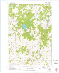 1973 Colburn1976 Print · USGSChippewa County is captured here in the early seventies, showing a landscape defined by the winding Yellow River and the township boundaries of Estella and Delmar. Researchers can locate the small settlement of Colburn and trace family roots at the Walker-Jackson Cem near the riverbanks.
 - 1973 Map of Crescent, 1977 Print
 1973 Crescent1977 Print · USGSChippewa County in the early seventies remains defined by its winding river valleys and rural crossroads settlements. Researchers can trace the heritage of small communities through landmarks like the Bohemian Cem, Cobban, and the Big Drywood Ch.
 - 1976 Map of Cadott NE, 1979 Print
 1976 Cadott NE1979 Print · USGSChippewa County agricultural life is captured in the mid-seventies, showing the precise layout of farmsteads and field lines across the Wisconsin countryside. Trace the development of Boyd and the rural crossroads of Edson Center along the winding path of the Yellow River.
 - 1979 Map of Cadott, 1980 Print
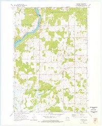
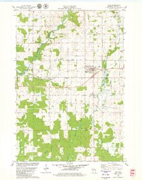
 1979 Cadott1980 Print · USGSCadott and the surrounding Wisconsin townships are shown in detail during the late 1970s, as the Yellow River shaped the local geography. Researchers can find several burial sites like St Rose Cem and Goetz Cem, or trace rural landmarks like the Crane Landing Strip.
 - 1979 Map of Boyd, 1980 Print
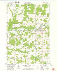
 1979 Boyd1980 Print · USGSChippewa County agriculture and industry are well-established in the late seventies as the rail lines and rivers shaped local commerce. Researchers can locate family sites near St Peter Cem or trace the early paths of the Soo Line and the Yellow River.
End of results
Showing maps 1-5 of 5
Top cities near Goetz
- Eau Claire historical maps
- Chippewa Falls historical maps
- Lake Hallie historical maps
- Town of Lafayette historical maps
- Stanley historical maps
- Eagle Point historical maps
See more
Frequently asked questions
- What are the different types of historical maps available for Goetz?
- What is the oldest map of Goetz?
- Where can I purchase historical maps of Goetz for my home or office?
- Where can I download high-res historical maps of Goetz?
- Are there historical topographic maps available for Goetz?
- Is there historical aerial imagery available for Goetz?
- Where are historical maps of Goetz sourced from?