1970s Maps of Sampson, Wisconsin
Explore 6 historic maps of Sampson from the 1970s. These maps offer a rare glimpse into what life looked like during the 1970s — showing old roads, neighborhoods, homes, and landmarks that have changed or disappeared over time.
Whether you're researching your family's past, planning a metal detecting trip, or studying how Sampson's landscape evolved across the 1970s, these high-resolution maps are a powerful tool for exploring the history of this region.
- Focus on a specific era: All maps on this page are from the 1970s, giving you a focused view of this time period.
- See what’s changed: Compare century-old streets, trails, and buildings to today's modern landscape using overlays and satellite layers.
- Research with precision: Use these maps for genealogy, historical research, land use analysis, or educational projects.
- View, download, or print: Maps are fully viewable online in high resolution, and can be downloaded or printed for your own records.
Start exploring Sampson's history through authentic maps from the 1970s. This is your window into the past.
Sampson, WI maps
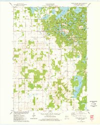
(6)- 1972 Map of Fireside Lakes, 1974 Print
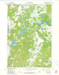 1972 Fireside Lakes1974 Print · USGSThe Chippewa River valley straddles the Rusk and Chippewa County line in the early seventies, a landscape of dense woods and glacial kettle lakes. Genealogists and local historians can trace the rural layout of Big Bend through sites like the Mud Lake Cem, Island Lake Ch, and Hatch Landing.
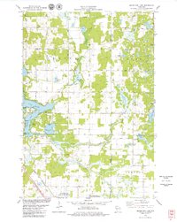
 - 1972 Map of Chain Lake, 1974 Print
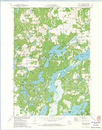 1972 Chain Lake1974 Print · USGSThe Northwoods of Wisconsin are captured in the early seventies, showcasing a dense network of glacial lakes and wilderness along the Rusk and Chippewa county line. Researchers can trace remote campsites like Two Bear Camp and local landmarks like Stang Lookout Tower or the Townhall.
 - 1975 Map of Bob Lake, 1978 Print
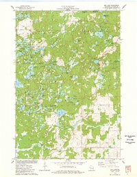 1975 Bob Lake1978 Print · USGSChippewa County is seen here in the mid-seventies, featuring the glacial landforms of the Chippewa Moraine. Researchers can locate community anchors like the Cleveland Cem and Trinity Ch, or trace the winding course of the Rustic Road.
 - 1975 Map of New Auburn, 1978 Print
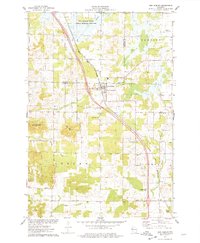 1975 New Auburn1978 Print · USGSWestern Wisconsin life in the mid-seventies centers on the village of New Auburn and its position along the Chicago and North Western railroad. Researchers can locate family sites at the New Auburn Cem, trace Duncan Creek, or explore the wooded Old Maids Bluff.
 - 1975 Map of Marsh-Miller Lake, 1978 Print
 1975 Marsh-Miller Lake1978 Print · USGSChippewa County is captured in the mid-seventies, revealing a glacial landscape defined by the Chippewa Moraine. Search for family roots at Tillinghast Cem or trace the shoreline developments of Marsh-Miller Lake and Long Lake.
 - 1978 Map of Moose Ear Lake, 1979 Print
 1978 Moose Ear Lake1979 Print · USGSNorthern Wisconsin lake country is captured here in the late seventies, showing the complex shorelines and rural life of the Chetek area. You can trace family history at the Johnson Cem or locate old community landmarks like Bass Lake Ch and the Chicago and North Western rail line.
End of results
Showing maps 1-6 of 6
Top cities near Sampson
- Bloomer historical maps
- Eagle Point historical maps
- Chetek historical maps
- Anson historical maps
- Tilden historical maps
- Thornapple historical maps
See more
Frequently asked questions
- What are the different types of historical maps available for Sampson?
- What is the oldest map of Sampson?
- Where can I purchase historical maps of Sampson for my home or office?
- Where can I download high-res historical maps of Sampson?
- Are there historical topographic maps available for Sampson?
- Is there historical aerial imagery available for Sampson?
- Where are historical maps of Sampson sourced from?