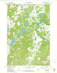
1972 Map of Fireside Lakes
USGS Topo · Published 1974About this map
The Chippewa River carves a sweeping path through the center of this landscape, marking the border between the townships of Big Bend and Washington. In the early 1970s, this region of the Rusk and Chippewa County line was defined by its intricate glaciated water system, including the namesake Fireside Lakes and the sprawling Washington Creek State Wildlife Management Area. The map reveals a cluster of small lakes to the south, such as No 1 Lake through No 4 Lake, suggesting a terrain shaped by kettles and moraines.
Find a feature on this map
48 named features on this map. Tap any name to fly to it.
Don’t see what you’re looking for? This feature index may not catch every label — zoom into the map to look around manually.
Map Details
Editions of this 1972 Fireside Lakes Map
This is the sole edition of this map. No revisions or reprints were ever made.
Other maps of this area

1948 · Weyerhauser
USGS Topo · 1:48,000

1948 · Ladysmith
USGS Topo · 1:48,000

1949 · Bloomer
USGS Topo · 1:62,500

1950 · Weyerhauser
USGS Topo · 1:48,000

1950 · Ladysmith
USGS Topo · 1:48,000

1951 · Bloomer
USGS Topo · 1:62,500

1951 · Cornell
USGS Topo · 1:62,500

1953 · Rice Lake
USGS Topo · 1:250,000

1959 · Rice Lake
USGS Topo · 1:250,000
1971 · Thornapple
USGS Topo · 1:24,000