
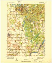
1951 Map of Bloomer
USGS Topo · Published 1951About this map
The Bloomer and Jim Falls areas of central Wisconsin show a post-war landscape defined by its glacial hydrology and rural social infrastructure. The northern half of the sheet is dominated by a dense collection of kettle lakes, including Marsh Miller Lake, Long Lake, and Bob Lake, where Camp Nawakwa and several schoolhouses like Bob Lake Sch and Point View Sch served local families. The Chicago and North Western railroad cuts through the southern reaches, connecting the industrial operations of the Chippewa River valley to the township of Bloomer. Genealogists will find a significant density of named country cemeteries, such as Tillinghast Cem, Ruffled Cem, and St Catherine Cem, alongside numerous small school districts such as Trout Creek Sch and Pine Corner Sch that have since consolidated. This era captures the transition of the region from purely agricultural townships like Woodmohr and Sampson toward more modern connectivity, evidenced by the Lakeland Airport.
Find a feature on this map
96 named features on this map. Tap any name to fly to it.
Don’t see what you’re looking for? This feature index may not catch every label — zoom into the map to look around manually.
Map Details
Editions of this 1951 Bloomer Map
2 editions found
Other maps of this area

1934 · Elk Mound
USGS Topo · 1:62,500

1934 · Chippewa Falls
USGS Topo · 1:62,500

1936 · Chippewa Falls
USGS Topo · 1:62,500

1936 · Elk Mound
USGS Topo · 1:62,500

1948 · Weyerhauser
USGS Topo · 1:48,000

1948 · Ladysmith
USGS Topo · 1:48,000

1949 · Bloomer
USGS Topo · 1:62,500

1949 · New Auburn
USGS Topo · 1:62,500

1950 · Weyerhauser
USGS Topo · 1:48,000

1950 · Ladysmith
USGS Topo · 1:48,000