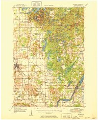
1951 Map of Bloomer
USGS Topo · Published 1951About this map
The Chippewa River flows through the southeastern corner of this landscape, marking the site of Jim Falls where the Chicago and North Western railroad crosses the water near a large Quarry. The terrain is defined by a dense concentration of glacial kettles and lakes, particularly in the northeast around Birch Creek and Sampson, where Long Lake and Marsh Miller Lake dominate the geography.
Find a feature on this map
101 named features on this map. Tap any name to fly to it.
Don’t see what you’re looking for? This feature index may not catch every label — zoom into the map to look around manually.
Map Details
Editions of this 1951 Bloomer Map
2 editions found

Other maps of this area

1934 · Elk Mound
USGS Topo · 1:62,500

1934 · Chippewa Falls
USGS Topo · 1:62,500

1936 · Chippewa Falls
USGS Topo · 1:62,500

1936 · Elk Mound
USGS Topo · 1:62,500

1948 · Weyerhauser
USGS Topo · 1:48,000

1948 · Ladysmith
USGS Topo · 1:48,000

1949 · Bloomer
USGS Topo · 1:62,500

1949 · New Auburn
USGS Topo · 1:62,500

1950 · Weyerhauser
USGS Topo · 1:48,000

1950 · Ladysmith
USGS Topo · 1:48,000