
1949 Map of Bloomer
USGS Topo · Published 1966About this map
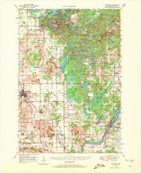
Bloomer and the surrounding townships of Sampson, Bloomer, and Woodmohr are documented here just after the war, showcasing a landscape of dense woodlots and small family farms. The Chicago and North Western railway cuts through the western portion of the region, connecting the primary settlement at Bloomer with outlying rural districts. The map reveals an incredible density of small school districts, including Mile Corner Sch, Larson Sch, and Modern Sch, illustrating the decentralized education system of the mid-20th century. To the east, the terrain transitions into a lake-studded wilderness around Long Lake, Mary Jane Lake, and Bob Lake, where Camp Nawakwa and several small cemeteries like Cleveland Cem reflect early 20th-century community life. The southern edge follows the Chippewa river near Jim Falls, showing a mix of agricultural progress and river-driven geography.
Find a feature on this map
109 named features on this map. Tap any name to fly to it.
Don’t see what you’re looking for? This feature index may not catch every label — zoom into the map to look around manually.
Map Details
Editions of this 1949 Bloomer Map
2 editions found
Other maps of this area

1934 · Elk Mound
USGS Topo · 1:62,500

1934 · Chippewa Falls
USGS Topo · 1:62,500

1936 · Chippewa Falls
USGS Topo · 1:62,500

1936 · Elk Mound
USGS Topo · 1:62,500

1948 · Weyerhauser
USGS Topo · 1:48,000

1948 · Ladysmith
USGS Topo · 1:48,000

1949 · New Auburn
USGS Topo · 1:62,500

1950 · Weyerhauser
USGS Topo · 1:48,000

1950 · Ladysmith
USGS Topo · 1:48,000

1951 · Bloomer
USGS Topo · 1:62,500