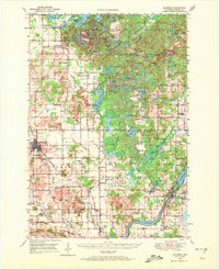
1949 Map of Bloomer
USGS Topo · Published 1972About this map
The Chicago And North Western railroad cuts a diagonal path through the southwestern portion of this 1949 survey, connecting the bustling hub of Bloomer to the surrounding agricultural landscape. To the south and east, the settlement of Jim Falls sits along the Chippewa river, characterized by the Spillway 856 and a nearby Gaging Sta. The northern half of the map is defined by an intricate network of kettle lakes, including Marsh Miller Lake, Cornell Lake, and Long Lake, interspersed with rural institutions like Maplewood Sch and Mission Ch. This area reflects a mid-century balance between established township centers like Tilden and recreational sites such as Camp Nawakwa and the YMCA Camp. Numerous family-named schools and cemeteries, such as Tillinghast Cem and Rutledge Cem, provide essential data points for tracing the early 20th-century rural population of Chippewa County.
Find a feature on this map
104 named features on this map. Tap any name to fly to it.
Don’t see what you’re looking for? This feature index may not catch every label — zoom into the map to look around manually.
Map Details
Editions of this 1949 Bloomer Map
2 editions found
Other maps of this area

1934 · Elk Mound
USGS Topo · 1:62,500

1934 · Chippewa Falls
USGS Topo · 1:62,500

1936 · Chippewa Falls
USGS Topo · 1:62,500

1936 · Elk Mound
USGS Topo · 1:62,500

1948 · Weyerhauser
USGS Topo · 1:48,000

1948 · Ladysmith
USGS Topo · 1:48,000

1949 · Bloomer
USGS Topo · 1:62,500

1949 · New Auburn
USGS Topo · 1:62,500

1950 · Weyerhauser
USGS Topo · 1:48,000

1950 · Ladysmith
USGS Topo · 1:48,000