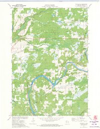
1971 Map of Thornapple
USGS Topo · Published 1973About this map
The Flambeau River carves a winding path through this corner of Rusk County, punctuated by the engineering of the Thornapple Dam and the riverside settlement of Port Arthur. This early 1970s landscape is a mix of active utility and receding industrial history, where the modern Soo Line tracks run parallel to a visible Old Railroad Grade that speaks to earlier logging or transit routes. The presence of the Ladysmith Lookout Tower and Air Village Landing Field indicates the area's role in regional fire monitoring and early aviation.
Find a feature on this map
25 named features on this map. Tap any name to fly to it.
Don’t see what you’re looking for? This feature index may not catch every label — zoom into the map to look around manually.
Map Details
Editions of this 1971 Thornapple Map
This is the sole edition of this map. No revisions or reprints were ever made.
Other maps of this area

1944 · Exeland
USGS Topo · 1:48,000

1945 · Meteor
USGS Topo · 1:48,000

1947 · Exeland
USGS Topo · 1:48,000

1948 · Weyerhauser
USGS Topo · 1:48,000

1948 · Ladysmith
USGS Topo · 1:48,000

1949 · Meteor
USGS Topo · 1:48,000

1950 · Weyerhauser
USGS Topo · 1:48,000

1950 · Ladysmith
USGS Topo · 1:48,000

1953 · Rice Lake
USGS Topo · 1:250,000

1959 · Rice Lake
USGS Topo · 1:250,000