
1945 Map of Meteor
USGS Topo · Published 1961About this map
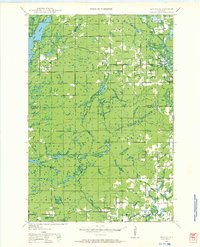
The Blue Hills rise above the forest and wetlands of the Meteor and Murray townships in this mid-century survey. The landscape is a complex network of glacial remnants, characterized by many small bodies of water like Deer Lake and Bucks Lake alongside more expansive waters such as Chetac Lake. The map details a transition in transportation, showing both active rail lines like the North Western and the Minneapolis St Paul and Sault Ste Marie, as well as an Old RR Grade already fading into the terrain north of Sucker Creek. Scattered rural schoolhouses, including Valley View Sch and Sentinel Ash Sch, serve the small communities of Edgewater and Yarnell, reflecting a dispersed settlement pattern typical of the era's timber and recreational economy.
Find a feature on this map
49 named features on this map. Tap any name to fly to it.
Don’t see what you’re looking for? This feature index may not catch every label — zoom into the map to look around manually.
Map Details
Editions of this 1945 Meteor Map
2 editions found
Other maps of this area

1944 · Exeland
USGS Topo · 1:48,000

1944 · Couderay
USGS Topo · 1:48,000

1944 · Radisson
USGS Topo · 1:48,000

1947 · Exeland
USGS Topo · 1:48,000

1948 · Couderay
USGS Topo · 1:48,000

1948 · Stone Lake
USGS Topo · 1:48,000

1948 · Weyerhauser
USGS Topo · 1:48,000

1948 · Ladysmith
USGS Topo · 1:48,000

1949 · Radisson
USGS Topo · 1:48,000

1949 · Meteor
USGS Topo · 1:48,000