1970s Maps of Butler, Wisconsin
Explore 2 historic maps of Butler from the 1970s. These maps offer a rare glimpse into what life looked like during the 1970s — showing old roads, neighborhoods, homes, and landmarks that have changed or disappeared over time.
Whether you're researching your family's past, planning a metal detecting trip, or studying how Butler's landscape evolved across the 1970s, these high-resolution maps are a powerful tool for exploring the history of this region.
- Focus on a specific era: All maps on this page are from the 1970s, giving you a focused view of this time period.
- See what’s changed: Compare century-old streets, trails, and buildings to today's modern landscape using overlays and satellite layers.
- Research with precision: Use these maps for genealogy, historical research, land use analysis, or educational projects.
- View, download, or print: Maps are fully viewable online in high resolution, and can be downloaded or printed for your own records.
Start exploring Butler's history through authentic maps from the 1970s. This is your window into the past.
Butler, WI maps
(2)- 1979 Map of Mead Lake West, 1980 Print
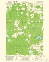 1979 Mead Lake West1980 Print · USGSClark County in the late seventies is captured here at the junction of the Eau Claire River forks and the recreation waters of Mead Lake. Genealogists and local historians can locate Butler Cem, the Townhall, and family-named water features like Dickison Creek.
 - 1979 Map of Simes Creek, 1980 Print
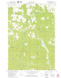 1979 Simes Creek1980 Print · USGSThe borderlands of Eau Claire, Chippewa, and Clark counties are mapped here in the late seventies. Researchers can locate specific rural landmarks such as Hamilton Falls, the Wilson Lookout Tower, and the Pleasant Valley Ch.
End of results
Showing maps 1-2 of 2
Top cities near Butler
- Stanley historical maps
- Thorp historical maps
- Edson historical maps
- Owen historical maps
- Colburn historical maps
- Reseburg historical maps
See more
Frequently asked questions
- What are the different types of historical maps available for Butler?
- What is the oldest map of Butler?
- Where can I purchase historical maps of Butler for my home or office?
- Where can I download high-res historical maps of Butler?
- Are there historical topographic maps available for Butler?
- Is there historical aerial imagery available for Butler?
- Where are historical maps of Butler sourced from?