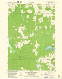
1979 Map of Mead Lake West
USGS Topo · Published 1980About this map
The North Fork Eau Claire River and South Fork Eau Claire River converge in this corner of Clark County, defining a landscape of wetlands and wooded uplands. In the late 1970s, the eastern portion of this map is dominated by Mead Lake, a prominent water body supporting recreation at North Mead Lake County Park and the Veterans Memorial County Park Camp. The map provides a clear record of local civic and community landmarks, including the centrally located Butler Cem and a nearby Townhall. Terrain features such as the Blue Swamp to the west and the elevations of North Mound and Middle Mound to the southeast frame the agricultural and timbered tracts of Butler and Mead townships. This survey serves as a precise document of rural infrastructure, from the local Sandpit and Gravel Pit operations to the major Pipeline corridor cutting through the southern timberlands.
Find a feature on this map
24 named features on this map. Tap any name to fly to it.
Don’t see what you’re looking for? This feature index may not catch every label — zoom into the map to look around manually.
Map Details
Editions of this 1979 Mead Lake West Map
This is the sole edition of this map. No revisions or reprints were ever made.
Other maps of this area

1948 · Fairchild
USGS Topo · 1:62,500

1949 · Fairchild
USGS Topo · 1:62,500

1952 · Stanley
USGS Topo · 1:62,500

1953 · Neillsville
USGS Topo · 1:62,500

1953 · Owen
USGS Topo · 1:48,000

1953 · Eau Claire
USGS Topo · 1:250,000

1958 · Eau Claire
USGS Topo · 1:250,000

1963 · Owen
USGS Topo · 1:62,500

1964 · Eau Claire
USGS Topo · 1:250,000
1976 · Stanley NE
USGS Topo · 1:24,000