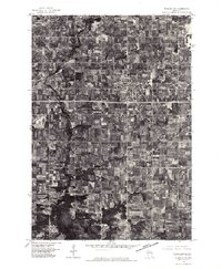
1976 Map of Stanley NE
USGS Topo · Published 1979About this map
Thorp sits at the center of this orthophotoquad, showing a clear grid of residential streets and industrial lots in the mid-1970s. The surrounding landscape of Clark County is a dense patchwork of agricultural fields and woodlots, bisected by the winding course of the North Fork Eau Claire River as it flows through the western portion of the quadrangle. Smaller rural centers like Eidsvold and Reseburg appear as distinct clusters among the farmsteads, providing a visual record of the region's dairy-country settlement patterns before modern development. Because this is an orthophotograph produced by the Geological Survey, it offers a precise aerial perspective on every farm pond, fenceline, and woodlot as they existed in April 1976.
Find a feature on this map
4 named features on this map. Tap any name to fly to it.
Don’t see what you’re looking for? This feature index may not catch every label — zoom into the map to look around manually.
Map Details
Editions of this 1976 Stanley NE Map
This is the sole edition of this map. No revisions or reprints were ever made.
Other maps of this area

1951 · Lublin
USGS Topo · 1:48,000

1951 · Gilman
USGS Topo · 1:62,500

1952 · Stanley
USGS Topo · 1:62,500

1953 · Owen
USGS Topo · 1:48,000

1953 · Eau Claire
USGS Topo · 1:250,000

1953 · Rice Lake
USGS Topo · 1:250,000

1958 · Eau Claire
USGS Topo · 1:250,000

1959 · Rice Lake
USGS Topo · 1:250,000

1963 · Owen
USGS Topo · 1:62,500

1964 · Eau Claire
USGS Topo · 1:250,000