1970s Maps of Levis, Wisconsin
Explore 4 historic maps of Levis from the 1970s. These maps offer a rare glimpse into what life looked like during the 1970s — showing old roads, neighborhoods, homes, and landmarks that have changed or disappeared over time.
Whether you're researching your family's past, planning a metal detecting trip, or studying how Levis's landscape evolved across the 1970s, these high-resolution maps are a powerful tool for exploring the history of this region.
- Focus on a specific era: All maps on this page are from the 1970s, giving you a focused view of this time period.
- See what’s changed: Compare century-old streets, trails, and buildings to today's modern landscape using overlays and satellite layers.
- Research with precision: Use these maps for genealogy, historical research, land use analysis, or educational projects.
- View, download, or print: Maps are fully viewable online in high resolution, and can be downloaded or printed for your own records.
Start exploring Levis's history through authentic maps from the 1970s. This is your window into the past.
Levis, WI maps
(4)- 1970 Map of Hatfield, 1972 Print
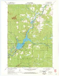 1970 Hatfield1972 Print · USGSThe Black River valley at the Clark and Jackson county line shows a landscape of state forests and river recreation in the early seventies. Genealogists and local historians can locate Hatfield, several cemeteries like Dells Dam Cem, and the old Clay School among the glacial mounds.2 unique versions available
 - 1970 Map of Hatfield NE, 1972 Print
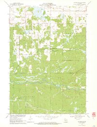 1970 Hatfield NE1972 Print · USGSCentral Wisconsin timber and marshlands appear in detail during the early seventies, centered on the community of Shortville. Researchers can trace the meandering path of the East Fork Black River and locate the drainage of Rock Creek through the surrounding township lands.3 unique versions available
 - 1979 Map of Neillsville, 1980 Print
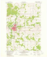 1979 Neillsville1980 Print · USGSNeillsville and the Black River valley are shown in the late 1970s as the local rail and industrial landscape remained active. Researchers can trace the Chicago and North Western line, locate the St John Sch, or explore the Neillsville Mounds.
 - 1979 Map of Columbia, 1980 Print
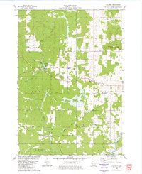 1979 Columbia1980 Print · USGSClark County woodland and rural settlements are captured here in the late seventies as the region maintained its timber and rail heritage. Genealogists and local historians can trace family-named roads and sites like Columbia, the Zion Ch, and the Old Railroad Grade.
End of results
Showing maps 1-4 of 4
Top cities near Levis
- Black River Falls historical maps
- Brockway historical maps
- Neillsville historical maps
- Lynn historical maps
- Merrillan historical maps
- Granton historical maps
See more
Frequently asked questions
- What are the different types of historical maps available for Levis?
- What is the oldest map of Levis?
- Where can I purchase historical maps of Levis for my home or office?
- Where can I download high-res historical maps of Levis?
- Are there historical topographic maps available for Levis?
- Is there historical aerial imagery available for Levis?
- Where are historical maps of Levis sourced from?