1960s Maps of Madison, Wisconsin
Explore 11 historic maps of Madison from the 1960s. These maps offer a rare glimpse into what life looked like during the 1960s — showing old roads, neighborhoods, homes, and landmarks that have changed or disappeared over time.
Whether you're researching your family's past, planning a metal detecting trip, or studying how Madison's landscape evolved across the 1960s, these high-resolution maps are a powerful tool for exploring the history of this region.
- Focus on a specific era: All maps on this page are from the 1960s, giving you a focused view of this time period.
- See what’s changed: Compare century-old streets, trails, and buildings to today's modern landscape using overlays and satellite layers.
- Research with precision: Use these maps for genealogy, historical research, land use analysis, or educational projects.
- View, download, or print: Maps are fully viewable online in high resolution, and can be downloaded or printed for your own records.
Start exploring Madison's history through authentic maps from the 1960s. This is your window into the past.
Madison, WI maps
(11)- 1960 Map of Madison
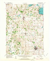
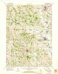
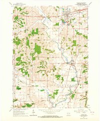
 1960 Madison1960 Print · USGSCentral and Southern Wisconsin are captured in the late fifties, showing the region as its rail-and-river network matured. Trace the paths of the Soo Line RR or locate family roots near Lake Mendota and Horicon National Wildlife Refuge.2 unique versions available
 - 1961 Map of Evansville, 1963 Print
 1961 Evansville1963 Print · USGSThe rural landscape between Madison and Janesville is captured here in the early sixties, showing a robust agricultural economy and well-defined town centers. Genealogists can trace family footprints at Franklin Sch, St Marys Cem, and the crossroads at Butts Corners.2 unique versions available
 - 1961 Map of Oregon, 1964 Print
 1961 Oregon1964 Print · USGSSouthern Dane County’s transition from rural farming to mid-century growth is detailed here in the early 1960s. Researchers can trace family roots through Story Cem and Oak Hall, or locate local landmarks like the Wisconsin School for Girls.4 unique versions available
 - 1962 Map of Cross Plains, 1964 Print
 1962 Cross Plains1964 Print · USGSWestern Dane County in the early sixties shows a landscape of deep valleys and rising ridges between Cross Plains and Mt Horeb. Genealogists and historians can trace family locations through numerous rural sites like St Marys Cem, Richardson Cave, and the Pine Bluff Observatory.2 unique versions available
 - 1962 Map of Sun Prairie, 1964 Print
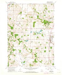
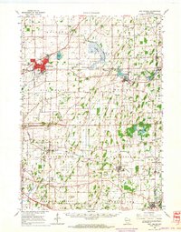
 1962 Sun Prairie1964 Print · USGSDane County farmland surrounds the growing village of Sun Prairie in the early sixties as it develops along the Milwaukee Road railroad. Genealogists and local historians can trace family locations near Pierceville, Bristol Ch, and Brazee Lake.5 unique versions available
 - 1962 Map of New Glarus, 1964 Print
 1962 New Glarus1964 Print · USGSSouthern Wisconsin's driftless terrain and Swiss-settled valleys are captured here in the early sixties, showing the rural character of Green and Dane Counties. Researchers can trace family history through sites like East Blue Mounds Church, Oak Hill Cem, and the Andrew Henry School.2 unique versions available
 - 1962 Map of Middleton, 1964 Print
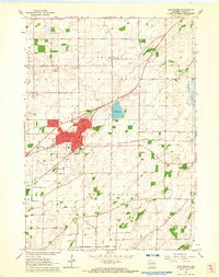
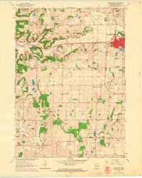 1962 Middleton1964 Print · USGSDane County underwent a period of significant post-war growth as the town of Middleton expanded along its historic rail lines. Researchers can trace local family history through numerous rural landmarks like St Johns Cem, the Drive-in Theater, and the West Middleton Sch.3 unique versions available
 - 1962 Map of Sun Prairie, 1964 Print
 1962 Sun Prairie1964 Print · USGSEastern Dane County thrives as a rail-connected agricultural region in the early sixties, centered on the growing community of Sun Prairie. Researchers can trace old family roots through numerous landmarks like the Prairie Queen Sch, York Center Ch, and the Liberty Prairie Cem.2 unique versions available
 - 1962 Map of Cottage Grove, 1964 Print
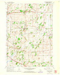 1962 Cottage Grove1964 Print · USGSCottage Grove and the surrounding Dane County townships are shown here in the early sixties, caught in an era of stable rural life and rail transport. Researchers can find precise locations for Cottage Grove Cem, the Largo Sch, and the winding course of Door Creek.5 unique versions available
 - 1962 Map of Verona, 1964 Print
 1962 Verona1964 Print · USGSThe countryside of central Dane County is captured in the early sixties as the village of Verona begins to grow around its historic rail connections. Genealogists and local historians can trace family-named landmarks and rural institutions like the Andrew Henry Sch, St Williams Cem, and the old Illinois Central line through Basco.3 unique versions available
 - 1963 Map of Rockford
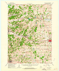
 1963 Rockford1963 Print · USGSThe mid-century industrial corridor along the Rock River is shown here during a period of rapid post-war growth. Researchers can trace the extensive rail lines of the Chicago and North Western or locate local landmarks like the Rockford Ordnance Depot and Holy Hill.
End of results
Showing maps 1-11 of 11
Top cities near Madison
- Sun Prairie historical maps
- Fitchburg historical maps
- Middleton historical maps
- Waunakee historical maps
- Stoughton historical maps
- DeForest historical maps
See more
Top neighborhoods of Madison
- Mendota Beach historical maps
- Hoepkers Corners historical maps
- Bowens Addition historical maps
- Mendota historical maps
- Middleton Junction historical maps
- Burke historical maps
See more
Frequently asked questions
- What are the different types of historical maps available for Madison?
- What is the oldest map of Madison?
- Where can I purchase historical maps of Madison for my home or office?
- Where can I download high-res historical maps of Madison?
- Are there historical topographic maps available for Madison?
- Is there historical aerial imagery available for Madison?
- Where are historical maps of Madison sourced from?