1980s Maps of Middleton, Wisconsin
Explore 3 historic maps of Middleton from the 1980s. These maps offer a rare glimpse into what life looked like during the 1980s — showing old roads, neighborhoods, homes, and landmarks that have changed or disappeared over time.
Whether you're researching your family's past, planning a metal detecting trip, or studying how Middleton's landscape evolved across the 1980s, these high-resolution maps are a powerful tool for exploring the history of this region.
- Focus on a specific era: All maps on this page are from the 1980s, giving you a focused view of this time period.
- See what’s changed: Compare century-old streets, trails, and buildings to today's modern landscape using overlays and satellite layers.
- Research with precision: Use these maps for genealogy, historical research, land use analysis, or educational projects.
- View, download, or print: Maps are fully viewable online in high resolution, and can be downloaded or printed for your own records.
Start exploring Middleton's history through authentic maps from the 1980s. This is your window into the past.
Middleton, WI maps
(3)- 1983 Map of Middleton, 1984 Print
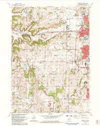 1983 Middleton1984 Print · USGSThe western suburbs of Madison are shown in the early eighties as they expanded into the hills of Dane County. Researchers can trace historical school sites like Kromrey Sch and the rail corridors of the Wisconsin Western and Chicago and North Western.
 - 1983 Map of Waunakee, 1984 Print
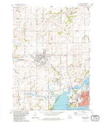 1983 Waunakee1984 Print · USGSThe north shore of Lake Mendota and the expanding village of Waunakee are captured here in the early eighties. Researchers can trace local lineage through the Vienna Cem and Kingsley Cem, or locate landmarks like the Mendota State Hospital and St. Mary of the Lake Sch.
 - 1983 Map of Madison West, 1984 Print
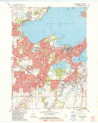 1983 Madison West1984 Print · USGSThe Madison isthmus and its surrounding lakefronts are shown in detail during the early eighties, from the State Capitol to the growing suburbs of Middleton. Researchers can trace the mid-century city layout, including the University of Wisconsin, Forest Hill Cemetery, and the Arboretum.
End of results
Showing maps 1-3 of 3
Top cities near Middleton
- Madison historical maps
- Sun Prairie historical maps
- Fitchburg historical maps
- Waunakee historical maps
- DeForest historical maps
- Verona historical maps
See more
Top neighborhoods of Middleton
- Clark's Addition historical maps
- Foxridge Hills historical maps
- Gamma West historical maps
- Harrop Addition historical maps
- Park Lawn historical maps
- Pheasant Branch Ridge historical maps
See more
Frequently asked questions
- What are the different types of historical maps available for Middleton?
- What is the oldest map of Middleton?
- Where can I purchase historical maps of Middleton for my home or office?
- Where can I download high-res historical maps of Middleton?
- Are there historical topographic maps available for Middleton?
- Is there historical aerial imagery available for Middleton?
- Where are historical maps of Middleton sourced from?