1950s Maps of Westford, Wisconsin
Explore 5 historic maps of Westford from the 1950s. These maps offer a rare glimpse into what life looked like during the 1950s — showing old roads, neighborhoods, homes, and landmarks that have changed or disappeared over time.
Whether you're researching your family's past, planning a metal detecting trip, or studying how Westford's landscape evolved across the 1950s, these high-resolution maps are a powerful tool for exploring the history of this region.
- Focus on a specific era: All maps on this page are from the 1950s, giving you a focused view of this time period.
- See what’s changed: Compare century-old streets, trails, and buildings to today's modern landscape using overlays and satellite layers.
- Research with precision: Use these maps for genealogy, historical research, land use analysis, or educational projects.
- View, download, or print: Maps are fully viewable online in high resolution, and can be downloaded or printed for your own records.
Start exploring Westford's history through authentic maps from the 1950s. This is your window into the past.
Westford, WI maps
(5)- 1955 Map of Randolph, 1956 Print
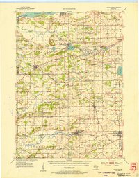 1955 Randolph1956 Print · USGSDodge and Columbia counties are seen here in the mid-fifties, dominated by prairie farming and the rail lines connecting towns like Friesland and Cambria. Researchers can trace the heritage of rural education and faith through sites like Penrhos Sch and Rosedale Ch.2 unique versions available
 - 1955 Map of Columbus, 1956 Print
 1955 Columbus1956 Print · USGSColumbia County’s dairy and rail corridor is captured here in the mid-fifties, centered on the growing community of Columbus. Genealogists can trace family names at St Joseph Cem or locate the many country schools like McKinley Sch and Hampden Sch.2 unique versions available
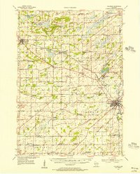
 - 1955 Map of Beaver Dam, 1957 Print
 1955 Beaver Dam1957 Print · USGSDodge County's rich agricultural and rail landscape is captured here in the mid-1950s. Genealogists can trace family roots through dozens of rural landmarks, from St Columbkille Cem to local schoolhouses like English Prairie Sch and Jackson Sch.2 unique versions available
 - 1955 Map of Fox Lake, 1957 Print
 1955 Fox Lake1957 Print · USGSIn the mid-1950s, the Dodge and Green Lake County borderlands were defined by a high density of one-room schoolhouses and rail-dependent towns. Trace family roots at Tichora Cem or follow the old Milwaukee Road tracks through Markesan and Fox Lake Junction.
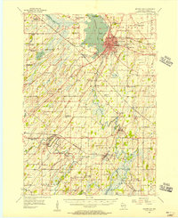
 - 1957 Map of Madison, 1967 Print
 1957 Madison1967 Print · USGSSouth-central Wisconsin in the mid-fifties reveals a landscape of industrial hubs and glacial lakes linked by a dense rail and highway network. Genealogists and historians can trace the development of lakeside communities and find notable sites like Badger Ordnance Works and the Horicon National Wildlife Refuge.3 unique versions available
End of results
Showing maps 1-5 of 5
Top cities near Westford
- Beaver Dam historical maps
- Columbus historical maps
- Waupun historical maps
- Juneau historical maps
- Fall River historical maps
- Fox Lake historical maps
See more
Top neighborhoods of Westford
Frequently asked questions
- What are the different types of historical maps available for Westford?
- What is the oldest map of Westford?
- Where can I purchase historical maps of Westford for my home or office?
- Where can I download high-res historical maps of Westford?
- Are there historical topographic maps available for Westford?
- Is there historical aerial imagery available for Westford?
- Where are historical maps of Westford sourced from?