1980s Maps of Northport, Liberty Grove
Explore 2 historic maps of Northport from the 1980s. These maps offer a rare glimpse into what life looked like during the 1980s — showing old roads, neighborhoods, homes, and landmarks that have changed or disappeared over time.
Whether you're researching your family's past, planning a metal detecting trip, or studying how Northport's landscape evolved across the 1980s, these high-resolution maps are a powerful tool for exploring the history of this region.
- Focus on a specific era: All maps on this page are from the 1980s, giving you a focused view of this time period.
- See what’s changed: Compare century-old streets, trails, and buildings to today's modern landscape using overlays and satellite layers.
- Research with precision: Use these maps for genealogy, historical research, land use analysis, or educational projects.
- View, download, or print: Maps are fully viewable online in high resolution, and can be downloaded or printed for your own records.
Start exploring Northport's history through authentic maps from the 1980s. This is your window into the past.
Northport, Liberty Grove maps
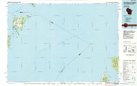
(2)- 1982 Map of Washington Island SW, 1983 Print
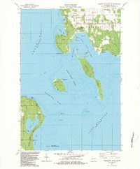 1982 Washington Island SW1983 Print · USGSDoor County's rugged island chain is documented here in the early 1980s, centered on the maritime gateway of Detroit Harbor. Researchers can trace the coastal landmarks of the era, from the U S Coast Guard Station on Plum Island to the quiet shores of Europe Lake.2 unique versions available
 - 1984 Map of Washington Island, 1985 Print
 1984 Washington Island1985 Print · USGSNorthern Door County and the Manitou Islands are mapped here in the mid-1980s, detailing a maritime landscape of remote archipelagoes. Researchers can trace the layout of Washington or locate Rock Island State Park and the rugged shores of North Manitou Island.2 unique versions available
End of results
Showing maps 1-2 of 2
Top cities near Northport
- Baileys Harbor historical maps
- Sister Bay historical maps
- Washington historical maps
- Ephraim historical maps
Frequently asked questions
- What are the different types of historical maps available for Northport?
- What is the oldest map of Northport?
- Where can I purchase historical maps of Northport for my home or office?
- Where can I download high-res historical maps of Northport?
- Are there historical topographic maps available for Northport?
- Is there historical aerial imagery available for Northport?
- Where are historical maps of Northport sourced from?