Old Maps of Washington, Wisconsin for Genealogy
Trace your family roots with 13 historic maps of Washington. These high-res maps reveal old neighborhoods, homesites, landmarks, and streets — helping you uncover where your ancestors lived and how the area evolved over time.
- Explore historic neighborhoods: Identify where your relatives may have lived in the 1800s or 1900s.
- Compare maps over time: Trace the changes in streets, buildings, and landmarks for multi-generational research.
- Perfect for genealogy & ancestry research: Used by family historians and researchers to map out lineage and migration.
These maps are an incredible resource for exploring your personal connection to Washington's past.
Washington, WI maps
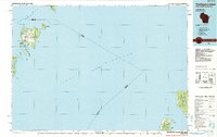
(13)- 1954 Map of Escanaba, 1967 Print
 1954 Escanaba1967 Print · USGSThe Upper Peninsula and Door County shorelines meet here in the mid-fifties, showing the vital maritime and timber networks of the Great Lakes. Researchers can trace historic rail lines, old fire lookouts like the Stonington Fire Tower, and island settlements such as Washington Island.2 unique versions available
 - 1957 Map of Escanaba
 1957 Escanaba1957 Print · USGSThe Upper Peninsula and Door County shorelines meet in the mid-fifties, capturing a landscape of timber, iron, and maritime trade. Genealogists and local historians can trace the Chicago & North Western RR through settlements like Hermansville or locate St Vitals Church and the Potawatome Indian Reservation.
 - 1958 Map of Escanaba
 1958 Escanaba1958 Print · USGSNorthern Lake Michigan maritime commerce and timberlands are captured here in the mid-fifties. Genealogists and historians can trace rail networks like the Escanaba and Lake Superior or locate island settlements such as Detroit Harbor and Fish Creek.
 - 1960 Map of Washington Island, 1962 Print
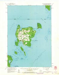 1960 Washington Island1962 Print · USGSDoor County’s northern archipelago appears here in the early sixties, showing the vital maritime connections between the mainland and the island communities. Genealogists and historians can locate Trinity Ch, the remote St Martin Cem, and early landmarks like Pottawatomie Light.2 unique versions available
 - 1982 Map of Washington Island SE
 1982 Washington Island SE1982 Print · USGSThe southeastern coast of Washington Island in the early eighties shows a landscape of coastal wetlands and protected islands. Researchers can trace the layout of Eastside County Park and the rugged offshore terrain of Fisherman Shoal and Hog Island.2 unique versions available
 - 1982 Map of Washington Island NW
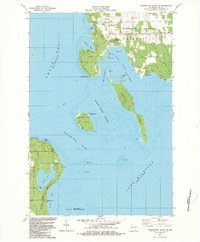
 1982 Washington Island NW1982 Print · USGSWashington Island's northwestern shores in the early eighties show a landscape of maritime navigation and island community life. Genealogists and local historians can locate the Township Cem, several island churches, and landmarks like the Lookout Tower and Boyer Bluff.2 unique versions available
 - 1982 Map of Washington Island NE, 1983 Print
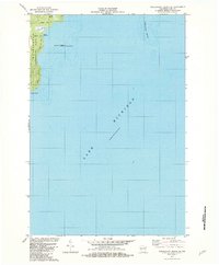
 1982 Washington Island NE1983 Print · USGSThe maritime frontier of Door County and Delta County is captured here in the early 1980s, documenting the remote outposts of the Green Bay entrance. Trace family roots at the Cem in Fairbanks or locate the historic Pottawatomie Light on Rock Island.2 unique versions available
 - 1982 Map of Washington Island SW, 1983 Print
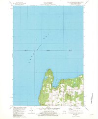
 1982 Washington Island SW1983 Print · USGSDoor County's rugged island chain is documented here in the early 1980s, centered on the maritime gateway of Detroit Harbor. Researchers can trace the coastal landmarks of the era, from the U S Coast Guard Station on Plum Island to the quiet shores of Europe Lake.2 unique versions available
 - 1984 Map of Washington Island, 1985 Print
 1984 Washington Island1985 Print · USGSNorthern Door County and the Manitou Islands are mapped here in the mid-1980s, detailing a maritime landscape of remote archipelagoes. Researchers can trace the layout of Washington or locate Rock Island State Park and the rugged shores of North Manitou Island.2 unique versions available
 - 2022 Map of Washington Island NW, 2022 Print
 2022 Washington Island NW2022 Print · USGSThe northern tip of Wisconsin’s Door Peninsula is captured here in the early 2020s, showing the quiet settlement patterns of Washington Island. Researchers can trace local lineage through sites like Island Cem or explore the coast near Bowyer Bluff and Little Lake.
 - 2022 Map of Washington Island SW, 2022 Print
 2022 Washington Island SW2022 Print · USGSThe waters surrounding southwestern Washington Island and the tip of the Door Peninsula are mapped here in the early twenty-first century. Researchers can trace the maritime corridors of Porte des Morts and find landmarks like Detroit Harbor, Plum Island, and Europe Lake.
 - 2022 Map of Washington Island NE, 2022 Print
 2022 Washington Island NE2022 Print · USGSThe islands and passages of the Door County archipelago are documented here in the early twenty-first century. Researchers can trace land tracts near Jackson Harbor or locate the historic Saint Martin Island Cem on the northern islands.
 - 2022 Map of Washington Island SE, 2022 Print
 2022 Washington Island SE2022 Print · USGSWashington Island at the edge of Lake Michigan is documented here in the early twenty-first century, showing the transition from island wetlands to the open lake. Researchers can trace land use near Big Marsh and identify property access along Old Mill Rd and Michigan Rd.
End of results
Showing maps 1-13 of 13
Top neighborhoods of Washington
Frequently asked questions
- What are the different types of historical maps available for Washington?
- What is the oldest map of Washington?
- Where can I purchase historical maps of Washington for my home or office?
- Where can I download high-res historical maps of Washington?
- Are there historical topographic maps available for Washington?
- Is there historical aerial imagery available for Washington?
- Where are historical maps of Washington sourced from?