Old Maps of Gordon, Wisconsin for Academic Research
Study the evolution of Gordon with 94 high-resolution historic maps. Whether you're teaching, researching, or modeling changes in land use, these maps provide essential visual documentation of urban, environmental, and geographic change.
- Analyze long-term change: Track patterns in development, transportation, and natural features.
- Ideal for environmental or urban studies: Support academic projects with primary historical map data.
- Use in the classroom or lab: Educators and researchers rely on these maps to bring historical context to life.
These maps are a powerful tool for teaching, research, and visualizing how Gordon has changed over the decades.
Gordon, WI maps
(94)- 1945 Map of Highland, 1956 Print
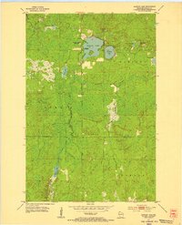
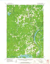
 1945 Highland1956 Print · USGSNorthwestern Wisconsin at the end of the war is revealed here through its intricate network of glacial lakes and northern forests. Researchers can pinpoint mid-century local landmarks like the Frances Willard Sch, Barnes Cem, and the path of the Brule River.
 - 1945 Map of Solon Springs, 1957 Print
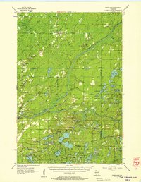
 1945 Solon Springs1957 Print · USGSWisconsin's headwaters region comes to life in the 1940s, showing the early infrastructure and wilderness of Douglas County. Researchers can trace the Old Portage Tr, locate the Sieur du Lhut Monument, and find vanished schoolhouses like Ibsen Sch.
 - 1947 Map of Chittamo, 1956 Print
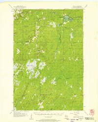
 1947 Chittamo1956 Print · USGSNorthwest Wisconsin's lake country is captured in the mid-1940s, showing a land of dense wetlands and winding river systems. Genealogists and historians can locate rural schoolhouses like Chittamo Sch and trace the original paths of the Totagatic River and Claire River.2 unique versions available
 - 1947 Map of Minong, 1964 Print
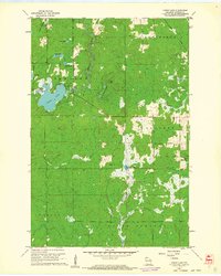
 1947 Minong1964 Print · USGSNorthwest Wisconsin's lake country is captured here in the late 1940s as rail and road corridors began to open the woods for more permanent settlement. Genealogists can locate family-named landmarks and rural hubs like Wascott Ch, Hoover Sch, and the village of Minong.
 - 1949 Map of Solon Springs
 1949 Solon Springs1949 Print · USGSNorthwestern Wisconsin at the end of the 1940s reveals a landscape of timber, rail, and water centered on the St. Croix headwaters. Genealogists and historians can locate rural landmarks like New Hawthorne Cem, Roosevelt Sch, and the Sieur du Lhut Monument near the rail lines at Sauntry.
 - 1949 Map of Chittamo
 1949 Chittamo1949 Print · USGSNorthwestern Wisconsin at the end of the 1940s shows a landscape of scattered settlements and winding rivers before modern development. Genealogists and historians can trace family locations near Chittamo Sch, Stanberry, and the Totagatic Dam.
 - 1949 Map of Minong
 1949 Minong1949 Print · USGSNorthwestern Wisconsin’s lake country is captured here in the late 1940s, when the North Western railroad still linked small timber and rail towns. Researchers can locate vanished landmarks like Hoover Sch, Wascott Ch, and the small settlement of Lakeside.
 - 1949 Map of Webb Lake
 1949 Webb Lake1949 Print · USGSNorthwest Wisconsin’s lake country is captured here in the late 1940s as rural life centered on the St Croix River. Researchers can trace old crossroads and remote outposts like Dairyland, Cozy Corners, and the historic Webb Lake Sch.
 - 1949 Map of Patzau
 1949 Patzau1949 Print · USGSNorthwestern Wisconsin’s Douglas County is captured here in the late 1940s, a landscape defined by the expansive Empire Swamp and active rail corridors. Genealogists and researchers can trace rural life through the locations of the Amnicon Lake School, the settlement of Patzau, and the Summit Firetower.
 - 1949 Map of Highland
 1949 Highland1949 Print · USGSDouglas County’s lake-strewn interior is captured here just after the war, showing a landscape defined by glacial waters and forestry. Genealogists can locate rural landmarks like the Frances Willard Sch, Barnes Cem, and the Barnes Town Hall.
 - 1953 Map of Ashland, 1964 Print
 1953 Ashland1964 Print · USGSNorthern Wisconsin's lakefront and timberlands are seen here in the mid-1950s, showing the intersection of industrial rail lines and vast wilderness. Genealogists and historians can trace the Soo Line through rail towns like Mellen or locate family roots in the Apostle Islands and Bad River Indian Reservation.3 unique versions available
 - 1953 Map of Duluth, 1964 Print
 1953 Duluth1964 Print · USGSNortheastern Minnesota and northwestern Wisconsin are shown here during a period of industrial maturity and expanding conservation. Genealogists and historians can trace rail-connected towns like McGrath and Wahkon, or locate heritage sites within the Fond du Lac Indian Reservation.2 unique versions available
 - 1954 Map of Amnicon Lake, 1955 Print
 1954 Amnicon Lake1955 Print · USGSDouglas County’s wilderness in the early fifties reveals a landscape of glacial lakes and remnants of early industry. Genealogists and historians can trace the Old Railroad Grade or locate the site of the Amnicon Lake Sch near the shores of Amnicon Lake.2 unique versions available
 - 1954 Map of Lyman Lake, 1955 Print
 1954 Lyman Lake1955 Print · USGSDouglas County’s dense timber and lake country is captured here during the mid-fifties, before major shoreline development. Trace the route of the Minneapolis St Paul and Sault Ste Marie railroad or locate early landmarks like Pikes Peak and Lyman Lake.
 - 1955 Map of Webb Lake, 1957 Print
 1955 Webb Lake1957 Print · USGSNorthwestern Wisconsin’s lake country is captured here in the mid-fifties, showing the confluence of the St. Croix and Namekagon rivers. Researchers can trace rural life through sites like Cozy Corner, the Webb Lake Sch, and the Dairyland Lookout Tower.2 unique versions available
 - 1955 Map of Patzau, 1957 Print
 1955 Patzau1957 Print · USGSDouglas County in the mid-fifties is characterized by its expansive wetlands and the meeting of major rail lines like the Great Northern Railroad. Genealogists can trace several old school sites, including McCreary Sch and Chaffey Sch, located near Moose Junction.3 unique versions available
 - 1958 Map of Ashland
 1958 Ashland1958 Print · USGSCoastal Wisconsin and the Michigan borderlands meet here in the late fifties, dominated by the timbered expanses and iron-rich ranges. Genealogists can trace family footprints in settlements like Odanah and Montreal, or locate landmarks such as the Coast Guard Station and Agricultural Experiment Station.
 - 1958 Map of Duluth
 1958 Duluth1958 Print · USGSNortheastern Minnesota and the Wisconsin borderlands are shown in detail during the late 1950s, centered on the bustling rail yards and ports of Duluth. You can trace the historic routes of the Soo Line and Duluth Missabe & Iron Range through small towns like McGrath, Bruno, and Wrenshall.
 - 1961 Map of Lyman Lake, 1962 Print
 1961 Lyman Lake1962 Print · USGSDouglas County’s wilderness in the early sixties is a landscape of glacial lakes and river forks waiting to be explored. Trace the drainage of the Amnicon River or locate remote landmarks like the Bennett Lookout Tower and Three Bucks Lakes.2 unique versions available
 - 1961 Map of Solon Springs, 1963 Print
 1961 Solon Springs1963 Print · USGSNorthern Wisconsin lake country is captured in the early sixties, centered on the community of Solon Springs and the headwaters of the St. Croix. Genealogists can locate Evergreen Cem and Bennett Cem while tracing the Chicago and North Western rail line.2 unique versions available
 - 1961 Map of Ellison Lake, 1963 Print
 1961 Ellison Lake1963 Print · USGSNorthern Wisconsin's lake country is captured in the early sixties as a center for conservation and recreation. Researchers can trace family history at the Barnes Cem or explore the wilderness around the Bois Brule River and Lake Nebagamon.2 unique versions available
 - 1965 Map of Minong, 1967 Print
 1965 Minong1967 Print · USGSWashburn and Douglas counties are shown here in the mid-sixties during a period of expanding forest management and rail-based commerce. Researchers can locate family sites and landmarks like Wascott Cemetery, Sutherland Landing Field, and the Minong settlement.
 - 1971 Map of Chittamo NE, 1973 Print
 1971 Chittamo NE1973 Print · USGSThe northwoods of Douglas and Bayfield counties are shown here in the early seventies, a landscape defined by complex river systems and township boundaries. Genealogists and outdoorsmen can trace the Totagatic River through the Totagatic River State Wildlife Management Area or locate landmarks like Goose Lake and Frog Creek Road.
 - 1971 Map of Chittamo, 1973 Print
 1971 Chittamo1973 Print · USGSNorthwestern Wisconsin at the start of the 1970s is revealed as a dense patchwork of waterways and forest at the Douglas and Washburn county line. Genealogists and historians can trace the Soo Line tracks through Chittamo or explore the wild edges of Sauntrys Pocket and the Ounce River.
 - 1980 Map of Sandstone
 1980 Sandstone1980 Print · USGSPine County and the Minnesota-Wisconsin borderlands are shown here in the early eighties as a region of dense state forests and river corridors. Genealogists and historians can trace rail-town development along the Burlington Northern including Sandstone, Askov, and Hinckley.
Showing maps 1-25 of 94
Top cities near Gordon
- Hawthorne historical maps
- Lake Nebagamon historical maps
- Wascott historical maps
- Maple historical maps
- Brule historical maps
- Bennett historical maps
See more
Top neighborhoods of Gordon
Frequently asked questions
- What are the different types of historical maps available for Gordon?
- What is the oldest map of Gordon?
- Where can I purchase historical maps of Gordon for my home or office?
- Where can I download high-res historical maps of Gordon?
- Are there historical topographic maps available for Gordon?
- Is there historical aerial imagery available for Gordon?
- Where are historical maps of Gordon sourced from?