1970s Maps of Red Cedar, Wisconsin
Explore 4 historic maps of Red Cedar from the 1970s. These maps offer a rare glimpse into what life looked like during the 1970s — showing old roads, neighborhoods, homes, and landmarks that have changed or disappeared over time.
Whether you're researching your family's past, planning a metal detecting trip, or studying how Red Cedar's landscape evolved across the 1970s, these high-resolution maps are a powerful tool for exploring the history of this region.
- Focus on a specific era: All maps on this page are from the 1970s, giving you a focused view of this time period.
- See what’s changed: Compare century-old streets, trails, and buildings to today's modern landscape using overlays and satellite layers.
- Research with precision: Use these maps for genealogy, historical research, land use analysis, or educational projects.
- View, download, or print: Maps are fully viewable online in high resolution, and can be downloaded or printed for your own records.
Start exploring Red Cedar's history through authentic maps from the 1970s. This is your window into the past.
Red Cedar, WI maps
(4)- 1972 Map of Menomonie North, 1975 Print
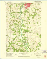
 1972 Menomonie North1975 Print · USGSDunn County in the early seventies shows a landscape of expanding university life and river-based industry. Locate family roots at Sherman Cem, trace the railroad to Menomonie Junction, or study the grounds of Stout State Univ.
 - 1972 Map of Rusk, 1975 Print
 1972 Rusk1975 Print · USGSDunn County in the early seventies shows a landscape where the Chicago and North Western railroad still connects rural towns. Genealogists can trace local roots through several family and community sites, including Hill Grove Cem, Potters Field Cem, and the St Katherine Ch Cem near Rusk.
 - 1972 Map of Menomonie South, 1975 Print
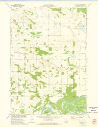
 1972 Menomonie South1975 Print · USGSDunn County at the start of the 1970s shows a landscape shaped by the Red Cedar River and the Milwaukee Road rail line. Genealogists and local historians can locate many rural cemeteries like Grandview Cem or explore the early campus of Stout State Univ.2 unique versions available
 - 1972 Map of Falls City, 1975 Print
 1972 Falls City1975 Print · USGSDunn County at the start of the 1970s reveals a landscape of active river bottoms and small-town landmarks. Genealogists and local historians can trace family ties at Falls City Cemetery, identify former school sites like Little Elk Creek School, and locate the C M St P & P rail line.
End of results
Showing maps 1-4 of 4
Top cities near Red Cedar
- Menomonie historical maps
- Union historical maps
- Town of Tainter historical maps
- Tainter historical maps
- Red Cedar historical maps
- Town of Red Cedar historical maps
See more
Top neighborhoods of Red Cedar
- Rusk historical maps
- Cedar Falls historical maps
- Town of Red Cedar historical maps
- Park Rapids historical maps
- Red Cedar Bend historical maps
- Cedar Falls Rapids historical maps
Frequently asked questions
- What are the different types of historical maps available for Red Cedar?
- What is the oldest map of Red Cedar?
- Where can I purchase historical maps of Red Cedar for my home or office?
- Where can I download high-res historical maps of Red Cedar?
- Are there historical topographic maps available for Red Cedar?
- Is there historical aerial imagery available for Red Cedar?
- Where are historical maps of Red Cedar sourced from?