1920s Maps of Green County, Wisconsin
Explore 5 historic maps of Green County from the 1920s. These maps offer a rare glimpse into what life looked like during the 1920s — showing old roads, neighborhoods, homes, and landmarks that have changed or disappeared over time.
Whether you're researching your family's past, planning a metal detecting trip, or studying how Green County's landscape evolved across the 1920s, these high-resolution maps are a powerful tool for exploring the history of this region.
- Focus on a specific era: All maps on this page are from the 1920s, giving you a focused view of this time period.
- See what’s changed: Compare century-old streets, trails, and buildings to today's modern landscape using overlays and satellite layers.
- Research with precision: Use these maps for genealogy, historical research, land use analysis, or educational projects.
- View, download, or print: Maps are fully viewable online in high resolution, and can be downloaded or printed for your own records.
Start exploring Green County's history through authentic maps from the 1920s. This is your window into the past.
Green County, WI maps
(5)- 1920 Map of Monroe, 1960 Print
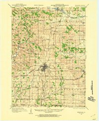 1920 Monroe1960 Print · USGSGreen County at the start of the twenties was a landscape of thriving rail towns and dozens of country schoolhouses. Genealogists can trace family footprints near named sites like Hardscrabble School, the County Farm, or along the Sugar River valley.
 - 1922 Map of Monroe
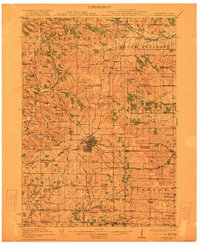 1922 Monroe1922 Print · USGSGreen County at the start of the twenties reveals a landscape of thriving rural school districts and busy rail lines. Genealogists can locate family-named landmarks like Hardscrabble School, the County Farm, and the early village of Juda.
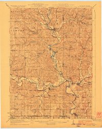
 - 1923 Map of Blanchardville
 1923 Blanchardville1923 Print · USGSThe Driftless Area of southwest Wisconsin comes alive in the early 1920s, showing a landscape defined by the Pecatonica River and early rail lines. Genealogists can locate dozens of rural landmarks, from the York Churches to schools like Lukken School and Arneson School.2 unique versions available
 - 1923 Map of New Glarus
 1923 New Glarus1923 Print · USGSGreen and Dane counties are captured here in the early 1920s, showing a region of family farms and emerging rail corridors. Genealogists can trace specific local landmarks like Primrose Churches, the County Farm, and dozens of rural schools including Hanna School.2 unique versions available
 - 1923 Map of South Wayne
 1923 South Wayne1923 Print · USGSSouthern Wisconsin and northern Illinois are shown in the early twenties as a landscape of interconnected river valleys and rail lines. Genealogists can trace dozens of country schoolhouses and churches, including Apple Grove Church, Reed School, and the community at South Wayne.3 unique versions available
End of results
Showing maps 1-5 of 5
Top cities of Green County
- Monroe historical maps
- Brodhead historical maps
- New Glarus historical maps
- Exeter historical maps
- Monticello historical maps
- Albany historical maps
See more
Frequently asked questions
- What are the different types of historical maps available for Green County?
- What is the oldest map of Green County?
- Where can I purchase historical maps of Green County for my home or office?
- Where can I download high-res historical maps of Green County?
- Are there historical topographic maps available for Green County?
- Is there historical aerial imagery available for Green County?
- Where are historical maps of Green County sourced from?