1960s Maps of Gurney, Wisconsin
Explore 3 historic maps of Gurney from the 1960s. These maps offer a rare glimpse into what life looked like during the 1960s — showing old roads, neighborhoods, homes, and landmarks that have changed or disappeared over time.
Whether you're researching your family's past, planning a metal detecting trip, or studying how Gurney's landscape evolved across the 1960s, these high-resolution maps are a powerful tool for exploring the history of this region.
- Focus on a specific era: All maps on this page are from the 1960s, giving you a focused view of this time period.
- See what’s changed: Compare century-old streets, trails, and buildings to today's modern landscape using overlays and satellite layers.
- Research with precision: Use these maps for genealogy, historical research, land use analysis, or educational projects.
- View, download, or print: Maps are fully viewable online in high resolution, and can be downloaded or printed for your own records.
Start exploring Gurney's history through authentic maps from the 1960s. This is your window into the past.
Gurney, WI maps
(3)- 1964 Map of Cedar, 1965 Print
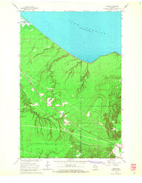 1964 Cedar1965 Print · USGSThe Lake Superior shoreline near the Ashland and Iron County border reveals a landscape of timber and rail in the mid-sixties. Researchers can trace the Chicago and North Western line through Cedar or locate the Birch Ridge Lookout Tower and Waverly Campground.2 unique versions available
 - 1964 Map of Odanah, 1966 Print
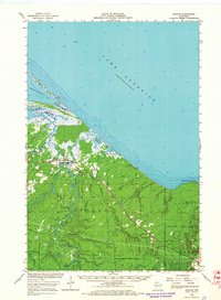 1964 Odanah1966 Print · USGSThe Lake Superior shoreline and the Bad River drainage are captured in the mid-1960s, showing the intersection of rail transit and coastal wetlands. Researchers can trace local history through Odanah, the Odanah Cem, and the Birch Ridge Lookout Tower.2 unique versions available
 - 1967 Map of Mellen, 1969 Print
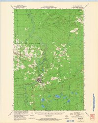 1967 Mellen1969 Print · USGSThe Mellen area in the late sixties reveals a landscape of deep-woods industry and northern rail towns. Genealogists and historians can trace the Soo Line through High Bridge or locate the Berkshire Mine Ruins and St Johns Cem.
End of results
Showing maps 1-3 of 3
Top cities near Gurney
Top neighborhoods of Gurney
Frequently asked questions
- What are the different types of historical maps available for Gurney?
- What is the oldest map of Gurney?
- Where can I purchase historical maps of Gurney for my home or office?
- Where can I download high-res historical maps of Gurney?
- Are there historical topographic maps available for Gurney?
- Is there historical aerial imagery available for Gurney?
- Where are historical maps of Gurney sourced from?