1970s Maps of Sherman, Wisconsin
Explore 5 historic maps of Sherman from the 1970s. These maps offer a rare glimpse into what life looked like during the 1970s — showing old roads, neighborhoods, homes, and landmarks that have changed or disappeared over time.
Whether you're researching your family's past, planning a metal detecting trip, or studying how Sherman's landscape evolved across the 1970s, these high-resolution maps are a powerful tool for exploring the history of this region.
- Focus on a specific era: All maps on this page are from the 1970s, giving you a focused view of this time period.
- See what’s changed: Compare century-old streets, trails, and buildings to today's modern landscape using overlays and satellite layers.
- Research with precision: Use these maps for genealogy, historical research, land use analysis, or educational projects.
- View, download, or print: Maps are fully viewable online in high resolution, and can be downloaded or printed for your own records.
Start exploring Sherman's history through authentic maps from the 1970s. This is your window into the past.
Sherman, WI maps
(5)- 1971 Map of Pike Lake, 1973 Print
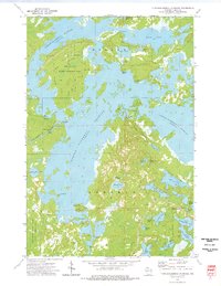
 1971 Pike Lake1973 Print · USGSIn the early 1970s, the lake country at the junction of Price, Iron, and Vilas counties was a landscape of deep forests and interconnected waterways. Researchers can trace the Chippewa Trail, locate the Lookout Tower on Sentinel Point, and explore the shorelines of Round Lake and Pike Lake.
 - 1971 Map of Lac Du Flambeau, 1973 Print
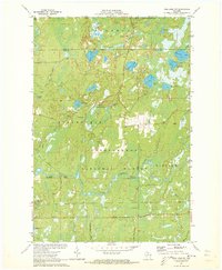
 1971 Lac Du Flambeau1973 Print · USGSLac du Flambeau and its surrounding lakes are captured here in the early seventies, showing a landscape defined by water and forest. Researchers can trace the Reservation Boundary and find local landmarks like the Indian Agency and Strawberry Island.3 unique versions available
 - 1971 Map of Pike Lake NW, 1973 Print
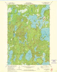
 1971 Pike Lake NW1973 Print · USGSPrice and Iron counties appear here in the early seventies, dominated by the timberlands of the Chequamegon National Forest. Genealogists and outdoorsmen can trace the South Fork Flambeau River past Smith Rapids Campground and identify seasonal sites like Camp Nine Springs.3 unique versions available
 - 1973 Map of Turtle-Flambeau Flowage, 1976 Print
 1973 Turtle-Flambeau Flowage1976 Print · USGSIron County's Northwoods landscape is captured here in the early 1970s, defined by the expansion of the Turtle-Flambeau Flowage. Genealogists and local historians can locate the Springstead settlement, the Townhall, and landmarks like the Springstead Lookout Tower.2 unique versions available
 - 1973 Map of Wilson Lake, 1976 Print
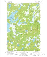 1973 Wilson Lake1976 Print · USGSIron County’s Northwoods are captured in the early seventies, a landscape dominated by the confluence of three major rivers and extensive protected wetlands. Researchers can locate remote landmarks like Murrays Landing, Bonies Mound, and Leach Lake.2 unique versions available
End of results
Showing maps 1-5 of 5
Top cities near Sherman
- Minocqua historical maps
- Lac du Flambeau historical maps
- Mercer historical maps
- Fifield historical maps
- Manitowish Waters historical maps
- Winchester historical maps
Top neighborhoods of Sherman
Frequently asked questions
- What are the different types of historical maps available for Sherman?
- What is the oldest map of Sherman?
- Where can I purchase historical maps of Sherman for my home or office?
- Where can I download high-res historical maps of Sherman?
- Are there historical topographic maps available for Sherman?
- Is there historical aerial imagery available for Sherman?
- Where are historical maps of Sherman sourced from?