1970s Maps of Waterbury, Komensky
Explore 1 historic maps of Waterbury from the 1970s. These maps offer a rare glimpse into what life looked like during the 1970s — showing old roads, neighborhoods, homes, and landmarks that have changed or disappeared over time.
Whether you're researching your family's past, planning a metal detecting trip, or studying how Waterbury's landscape evolved across the 1970s, these high-resolution maps are a powerful tool for exploring the history of this region.
- Focus on a specific era: All maps on this page are from the 1970s, giving you a focused view of this time period.
- See what’s changed: Compare century-old streets, trails, and buildings to today's modern landscape using overlays and satellite layers.
- Research with precision: Use these maps for genealogy, historical research, land use analysis, or educational projects.
- View, download, or print: Maps are fully viewable online in high resolution, and can be downloaded or printed for your own records.
Start exploring Waterbury's history through authentic maps from the 1970s. This is your window into the past.
Waterbury, Komensky maps
(1)- 1970 Map of Hatfield NE, 1972 Print
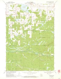 1970 Hatfield NE1972 Print · USGSCentral Wisconsin timber and marshlands appear in detail during the early seventies, centered on the community of Shortville. Researchers can trace the meandering path of the East Fork Black River and locate the drainage of Rock Creek through the surrounding township lands.3 unique versions available
End of results
Showing maps 1-1 of 1
Top cities near Waterbury
- Black River Falls historical maps
- Brockway historical maps
- Neillsville historical maps
- Lynn historical maps
- Merrillan historical maps
- Granton historical maps
See more
Frequently asked questions
- What are the different types of historical maps available for Waterbury?
- What is the oldest map of Waterbury?
- Where can I purchase historical maps of Waterbury for my home or office?
- Where can I download high-res historical maps of Waterbury?
- Are there historical topographic maps available for Waterbury?
- Is there historical aerial imagery available for Waterbury?
- Where are historical maps of Waterbury sourced from?