1970s Maps of Mather, Kingston
Explore 1 historic maps of Mather from the 1970s. These maps offer a rare glimpse into what life looked like during the 1970s — showing old roads, neighborhoods, homes, and landmarks that have changed or disappeared over time.
Whether you're researching your family's past, planning a metal detecting trip, or studying how Mather's landscape evolved across the 1970s, these high-resolution maps are a powerful tool for exploring the history of this region.
- Focus on a specific era: All maps on this page are from the 1970s, giving you a focused view of this time period.
- See what’s changed: Compare century-old streets, trails, and buildings to today's modern landscape using overlays and satellite layers.
- Research with precision: Use these maps for genealogy, historical research, land use analysis, or educational projects.
- View, download, or print: Maps are fully viewable online in high resolution, and can be downloaded or printed for your own records.
Start exploring Mather's history through authentic maps from the 1970s. This is your window into the past.
Mather, Kingston maps
(1)- 1970 Map of Mather, 1972 Print
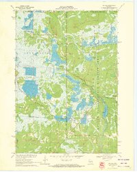 1970 Mather1972 Print · USGSThe cranberry bogs and flowages of Juneau County are at their peak development in this 1970s record of the central Wisconsin marshes. Genealogists and historians can locate Mather, the Oak Grove Cem, and the old rail-aligned settlement of Norway Ridge.
End of results
Showing maps 1-1 of 1
Top cities near Mather
- Tomah historical maps
- Necedah historical maps
- Camp Douglas historical maps
- Oakdale historical maps
- Cutler historical maps
- Warrens historical maps
See more
Frequently asked questions
- What are the different types of historical maps available for Mather?
- What is the oldest map of Mather?
- Where can I purchase historical maps of Mather for my home or office?
- Where can I download high-res historical maps of Mather?
- Are there historical topographic maps available for Mather?
- Is there historical aerial imagery available for Mather?
- Where are historical maps of Mather sourced from?