1970s Maps of East Krok, West Kewaunee
Explore 1 historic maps of East Krok from the 1970s. These maps offer a rare glimpse into what life looked like during the 1970s — showing old roads, neighborhoods, homes, and landmarks that have changed or disappeared over time.
Whether you're researching your family's past, planning a metal detecting trip, or studying how East Krok's landscape evolved across the 1970s, these high-resolution maps are a powerful tool for exploring the history of this region.
- Focus on a specific era: All maps on this page are from the 1970s, giving you a focused view of this time period.
- See what’s changed: Compare century-old streets, trails, and buildings to today's modern landscape using overlays and satellite layers.
- Research with precision: Use these maps for genealogy, historical research, land use analysis, or educational projects.
- View, download, or print: Maps are fully viewable online in high resolution, and can be downloaded or printed for your own records.
Start exploring East Krok's history through authentic maps from the 1970s. This is your window into the past.
East Krok, West Kewaunee maps
(1)- 1978 Map of Kewaunee, 1979 Print
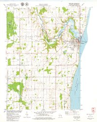 1978 Kewaunee1979 Print · USGSThe Lake Michigan shoreline and Kewaunee River valley are shown here in the late seventies, detailing the region's transition from harbor town to rural countryside. Researchers can trace family sites at St Peters Ch Cem, the rail lines of the Green Bay and Western, and local landmarks like Bruemmer Co Park.
End of results
Showing maps 1-1 of 1
Top cities near East Krok
- Algoma historical maps
- Kewaunee historical maps
- Luxemburg historical maps
- Denmark historical maps
- Humboldt historical maps
- Mishicot historical maps
See more
Frequently asked questions
- What are the different types of historical maps available for East Krok?
- What is the oldest map of East Krok?
- Where can I purchase historical maps of East Krok for my home or office?
- Where can I download high-res historical maps of East Krok?
- Are there historical topographic maps available for East Krok?
- Is there historical aerial imagery available for East Krok?
- Where are historical maps of East Krok sourced from?