1960s Maps of Hamilton, Wisconsin
Explore 7 historic maps of Hamilton from the 1960s. These maps offer a rare glimpse into what life looked like during the 1960s — showing old roads, neighborhoods, homes, and landmarks that have changed or disappeared over time.
Whether you're researching your family's past, planning a metal detecting trip, or studying how Hamilton's landscape evolved across the 1960s, these high-resolution maps are a powerful tool for exploring the history of this region.
- Focus on a specific era: All maps on this page are from the 1960s, giving you a focused view of this time period.
- See what’s changed: Compare century-old streets, trails, and buildings to today's modern landscape using overlays and satellite layers.
- Research with precision: Use these maps for genealogy, historical research, land use analysis, or educational projects.
- View, download, or print: Maps are fully viewable online in high resolution, and can be downloaded or printed for your own records.
Start exploring Hamilton's history through authentic maps from the 1960s. This is your window into the past.
Hamilton, WI maps
(7)- 1961 Map of La Crosse
 1961 La Crosse1961 Print · USGSThe Driftless Area at the start of the 1960s reveals a complex network of river towns and rail lines along the Mississippi River. Genealogists and historians can trace old settlements like New Amsterdam and Wyattville or locate major landmarks like Camp McCoy Military Reservation and Effigy Mounds National Monument.
 - 1963 Map of Onalaska, 1964 Print
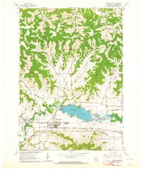
 1963 Onalaska1964 Print · USGSOnalaska and the Black River bottoms are captured here in the early sixties, showing the transition from river life to the upland coulee country. Researchers can trace rural school locations like Halfway Sch, family-named landmarks like Jostad Coulee, and local sites such as the Halfway Creek Cem.2 unique versions available
 - 1963 Map of St. Joseph, 1964 Print
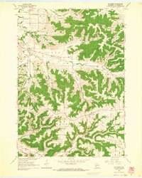 1963 St. Joseph1964 Print · USGSLa Crosse County's ridge-and-valley landscape is documented here in the early sixties, showing the rural townships before modern expansion. Researchers can find many family-era landmarks, from the St Johns Cem and Barre Mills to schools like Sunny Mede Sch.2 unique versions available
 - 1963 Map of La Crosse, 1964 Print
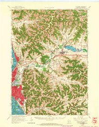
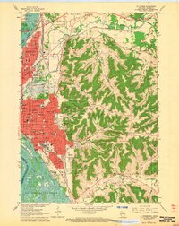 1963 La Crosse1964 Print · USGSLa Crosse is shown here in the early sixties as a bustling rail and river hub transitioning into a modern collegiate and medical center. Researchers can trace the layout of the city's many schools and hospitals, such as Aquinas High Sch and St Francis Hospital, or find family plots in the Catholic Cem.2 unique versions available
 - 1963 Map of West Salem, 1964 Print
 1963 West Salem1964 Print · USGSWest Salem and the surrounding coulee country are captured here in the early sixties as the modern interstate era begins to reshape the valley. Genealogists and local historians can trace rural landmarks from Bell Coulee Ch to the Neshonoc Cem and the busy rail corridors of the Bangor area.2 unique versions available
 - 1963 Map of La Crosse, 1965 Print
 1963 La Crosse1965 Print · USGSLa Crosse and the Mississippi River bluffs are captured here in the early sixties, showing the complex interplay of rail lines and river commerce. Genealogists and local historians can trace small rural schools like Halfway Creek Sch and landmarks such as Granddad Bluff or the Holy Cross Seminary.3 unique versions available
 - 1965 Map of La Crosse
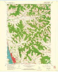
 1965 La Crosse1965 Print · USGSThe Driftless Area and the Upper Mississippi valley are captured here during a period of steady mid-century growth. Researchers can trace the rail lines of the Chicago and North Western or locate riverfront sites like Effigy Mounds National Monument and the Camp McCoy Military Reservation.
End of results
Showing maps 1-7 of 7
Top cities near Hamilton
- La Crosse historical maps
- Onalaska historical maps
- Holmen historical maps
- Sparta historical maps
- West Salem historical maps
- La Crescent historical maps
See more
Frequently asked questions
- What are the different types of historical maps available for Hamilton?
- What is the oldest map of Hamilton?
- Where can I purchase historical maps of Hamilton for my home or office?
- Where can I download high-res historical maps of Hamilton?
- Are there historical topographic maps available for Hamilton?
- Is there historical aerial imagery available for Hamilton?
- Where are historical maps of Hamilton sourced from?