1970s Maps of Polar, Wisconsin
Explore 4 historic maps of Polar from the 1970s. These maps offer a rare glimpse into what life looked like during the 1970s — showing old roads, neighborhoods, homes, and landmarks that have changed or disappeared over time.
Whether you're researching your family's past, planning a metal detecting trip, or studying how Polar's landscape evolved across the 1970s, these high-resolution maps are a powerful tool for exploring the history of this region.
- Focus on a specific era: All maps on this page are from the 1970s, giving you a focused view of this time period.
- See what’s changed: Compare century-old streets, trails, and buildings to today's modern landscape using overlays and satellite layers.
- Research with precision: Use these maps for genealogy, historical research, land use analysis, or educational projects.
- View, download, or print: Maps are fully viewable online in high resolution, and can be downloaded or printed for your own records.
Start exploring Polar's history through authentic maps from the 1970s. This is your window into the past.
Polar, WI maps
(4)- 1973 Map of Bryant, 1976 Print
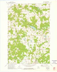
 1973 Bryant1976 Print · USGSLanglade County's agricultural and forest lands are captured in the early seventies, showing a landscape defined by its rural townships and timber history. Genealogists and researchers can trace local landmarks like Bent Cem, Spring Valley Sch, and the Old Railroad Grade.
 - 1973 Map of Mattoon, 1976 Print
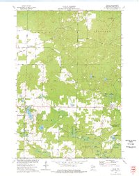
 1973 Mattoon1976 Print · USGSIn the early 1970s, the borderlands of Langlade and Shawano counties featured a landscape of conservation and small-town industry. Trace family roots in Mattoon and Phlox, or locate landmarks like the Norwood Cem and the Old Railroad Grade.2 unique versions available
 - 1973 Map of Polar, 1977 Print
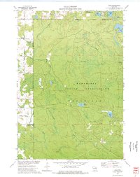
 1973 Polar1977 Print · USGSLanglade County in the early seventies reveals a landscape of spring-fed flowages and quiet settlements. Researchers can trace the Old Railroad Grade past Sherry Junction or locate family sites near the Sherry Cem and Elton.
 - 1973 Map of Zoar, 1977 Print
 1973 Zoar1977 Print · USGSThe Menominee Indian Reservation and the settlement of Zoar are shown here in the early 1970s amidst a landscape of glacial lakes and northern forests. Researchers can trace the Old Railroad Grade and locate specific features like Chisel Springs and Lake Neconish.
End of results
Showing maps 1-4 of 4
Top cities near Polar
- Antigo historical maps
- Elcho historical maps
- Nashville historical maps
- Neva historical maps
- Neopit historical maps
- Birnamwood historical maps
See more
Frequently asked questions
- What are the different types of historical maps available for Polar?
- What is the oldest map of Polar?
- Where can I purchase historical maps of Polar for my home or office?
- Where can I download high-res historical maps of Polar?
- Are there historical topographic maps available for Polar?
- Is there historical aerial imagery available for Polar?
- Where are historical maps of Polar sourced from?