1940s Maps of Somo, Wisconsin
Explore 6 historic maps of Somo from the 1940s. These maps offer a rare glimpse into what life looked like during the 1940s — showing old roads, neighborhoods, homes, and landmarks that have changed or disappeared over time.
Whether you're researching your family's past, planning a metal detecting trip, or studying how Somo's landscape evolved across the 1940s, these high-resolution maps are a powerful tool for exploring the history of this region.
- Focus on a specific era: All maps on this page are from the 1940s, giving you a focused view of this time period.
- See what’s changed: Compare century-old streets, trails, and buildings to today's modern landscape using overlays and satellite layers.
- Research with precision: Use these maps for genealogy, historical research, land use analysis, or educational projects.
- View, download, or print: Maps are fully viewable online in high resolution, and can be downloaded or printed for your own records.
Start exploring Somo's history through authentic maps from the 1940s. This is your window into the past.
Somo, WI maps
(6)- 1941 Map of Brantwood, 1971 Print
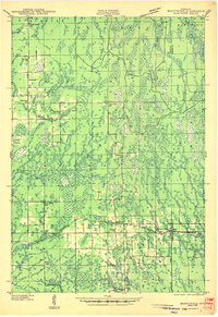
 1941 Brantwood1971 Print · USGSNorth-central Wisconsin is captured here in the early 1940s as a landscape of timber and rail-line settlements. You can trace the rural school system through Lone Corner Sch and Dover 3-E Sch, or locate family sites at Emery Cem and Brantwood.
 - 1943 Map of Brantwood
 1943 Brantwood1943 Print · USGSPrice and Oneida counties are shown here just after the start of the war, when the Minneapolis St Paul and Sault Ste Marie rail line anchored a series of rural timber and farming hamlets. Genealogists can locate numerous local landmarks like St Marys Cem, the Knox Mills Sch, and the vanished site of Jordan.2 unique versions available
 - 1945 Map of Rib Lake
 1945 Rib Lake1945 Print · USGSNorthern Wisconsin lake country is captured here during the 1940s, showing a landscape of timber and township life. Genealogists can locate rural landmarks like Spirit Town Hall, Mission Ch, and schools like Ring Sch or Stone Lake Sch.
 - 1947 Map of Mc Cord
 1947 Mc Cord1947 Print · USGSOneida and Lincoln counties come into focus during the late 1930s and 1940s as a landscape of timber, rail, and water. Genealogists and historians can locate rural schoolhouses like Lund Sch, the CCC Camp at Mc Cord, and the Prairie Rapids Ch.
 - 1947 Map of Rib Lake, 1956 Print
 1947 Rib Lake1956 Print · USGSTaylor and Price Counties come into focus during the late 1940s, a period when the timber industry and small-town life shaped this north-central Wisconsin landscape. Genealogists can trace family footprints through rural landmarks like Mission Ch, Stone Lake Sch, and the village of Rib Lake.
 - 1949 Map of Rib Lake
 1949 Rib Lake1949 Print · USGSRib Lake and the surrounding Northwoods townships appear here in the late 1940s, just as the rural schoolhouse system remained a central pillar of the community. Genealogists and historians can locate numerous local landmarks like Ring Sch, the Wilderness Lookout Tower, and the Mission Ch.
End of results
Showing maps 1-6 of 6
Top cities near Somo
- Minocqua historical maps
- Tomahawk historical maps
- Bradley historical maps
- Hazelhurst historical maps
- Rib Lake historical maps
- Spirit historical maps
Top neighborhoods of Somo
Frequently asked questions
- What are the different types of historical maps available for Somo?
- What is the oldest map of Somo?
- Where can I purchase historical maps of Somo for my home or office?
- Where can I download high-res historical maps of Somo?
- Are there historical topographic maps available for Somo?
- Is there historical aerial imagery available for Somo?
- Where are historical maps of Somo sourced from?