1900s (20th Century) Maps of Mishicot, Wisconsin
Explore 9 historic maps of Mishicot from the 1900s (20th Century). These maps offer a rare glimpse into what life looked like during the 1900s — showing old roads, neighborhoods, homes, and landmarks that have changed or disappeared over time.
Whether you're researching your family's past, planning a metal detecting trip, or studying how Mishicot's landscape evolved across the 1900s, these high-resolution maps are a powerful tool for exploring the history of this region.
- Focus on a specific era: All maps on this page are from the 1900s, giving you a focused view of this time period.
- See what’s changed: Compare century-old streets, trails, and buildings to today's modern landscape using overlays and satellite layers.
- Research with precision: Use these maps for genealogy, historical research, land use analysis, or educational projects.
- View, download, or print: Maps are fully viewable online in high resolution, and can be downloaded or printed for your own records.
Start exploring Mishicot's history through authentic maps from the 1900s. This is your window into the past.
Mishicot, WI maps
(9)- 1954 Map of Kewaunee, 1956 Print
 1954 Kewaunee1956 Print · USGSCoastal Kewaunee County and northern Manitowoc County appear here in the mid-fifties, dominated by small farm settlements and a dense network of rural schoolhouses. Genealogists can trace family roots through numerous sites like Chernesville Cem, St Peters Ch, and Tisch Mills.2 unique versions available
 - 1954 Map of Manitowoc, 1956 Print
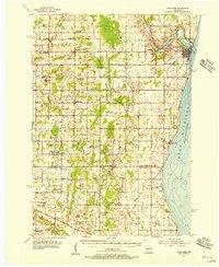
 1954 Manitowoc1956 Print · USGSThe Lake Michigan shoreline of Manitowoc and Two Rivers is captured here in the mid-1950s, showing a landscape of maritime industry and rural school districts. Genealogists can locate family landmarks like the Holy Family Convent, Francis Creek National Cem, and the Salem Sch (Abandoned).2 unique versions available
 - 1954 Map of Manitowoc, 1968 Print
 1954 Manitowoc1968 Print · USGSLake Michigan served as a vital transit corridor in the mid-fifties, with car and auto ferries linking the industrial ports of Wisconsin to the Michigan timberlands. Genealogists and maritime historians can trace active ferry routes like the Ann Arbor Railway Car and Auto Ferry and locate early settlements from Brussels to Algoma.2 unique versions available
 - 1958 Map of Manitowoc
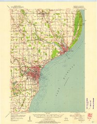
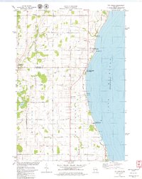
 1958 Manitowoc1958 Print · USGSLake Michigan and its shorelines are shown in the late fifties when maritime transport defined the region. Researchers can trace the routes of the Ann Arbor Railroad Ferry or locate old settlements like St. Nazianz, Rostock, and Two Creeks.
 - 1978 Map of Two Rivers, 1979 Print
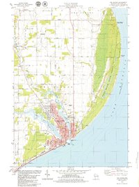 1978 Two Rivers1979 Print · USGSWisconsin's lakeside industry and rural heritage meet in the late seventies as the Twin Rivers join at the Lake Michigan shore. Genealogists and local historians can trace family-named sites like the Englebert Farms Landing Strip and several burial grounds, including Saxonburg Cem and Holy Cross Cem.
 - 1978 Map of Larrabee, 1979 Print
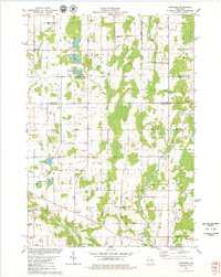 1978 Larrabee1979 Print · USGSThe rural borderlands of Manitowoc and Kewaunee counties are captured here in the late seventies, showing a landscape of family farms and glacial lakes. Genealogists can trace family names and local landmarks like Tisch Mills, St Johns Sch, and the German Cem.
 - 1978 Map of Mishicot, 1979 Print
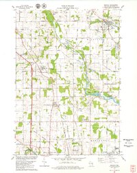 1978 Mishicot1979 Print · USGSManitowoc County in the late seventies is characterized by the intersection of the Twin Rivers and a landscape of busy gravel quarries. Researchers can trace family history at the Francis Creek National Cem or follow the C & NW RR through Francis Creek.
 - 1978 Map of Two Creeks, 1979 Print
 1978 Two Creeks1979 Print · USGSThe western shore of Lake Michigan is captured here in the late seventies as local energy production and lakefront preservation define the coast. Genealogists can trace family footprints around Norman, Tisch Mills, and the Sandy Bay Cemetery near the lake.2 unique versions available
 - 1984 Map of Manitowoc, 1985 Print
 1984 Manitowoc1985 Print · USGSThe Lake Michigan shoreline of eastern Wisconsin is captured here in the mid-eighties, showing the bustling ports and rail-fed industry of the era. Genealogists and researchers can trace family-named sites near Stangelville, find the Francis Creek National Cem, or locate the U S Coast Guard Station.2 unique versions available
End of results
Showing maps 1-9 of 9
Top cities near Mishicot
- Green Bay historical maps
- Manitowoc historical maps
- Two Rivers historical maps
- Kewaunee historical maps
- Newton historical maps
- Denmark historical maps
See more
Frequently asked questions
- What are the different types of historical maps available for Mishicot?
- What is the oldest map of Mishicot?
- Where can I purchase historical maps of Mishicot for my home or office?
- Where can I download high-res historical maps of Mishicot?
- Are there historical topographic maps available for Mishicot?
- Is there historical aerial imagery available for Mishicot?
- Where are historical maps of Mishicot sourced from?