1990s Maps of St. Nazianz, Wisconsin
Explore 2 historic maps of St. Nazianz from the 1990s. These maps offer a rare glimpse into what life looked like during the 1990s — showing old roads, neighborhoods, homes, and landmarks that have changed or disappeared over time.
Whether you're researching your family's past, planning a metal detecting trip, or studying how St. Nazianz's landscape evolved across the 1990s, these high-resolution maps are a powerful tool for exploring the history of this region.
- Focus on a specific era: All maps on this page are from the 1990s, giving you a focused view of this time period.
- See what’s changed: Compare century-old streets, trails, and buildings to today's modern landscape using overlays and satellite layers.
- Research with precision: Use these maps for genealogy, historical research, land use analysis, or educational projects.
- View, download, or print: Maps are fully viewable online in high resolution, and can be downloaded or printed for your own records.
Start exploring St. Nazianz's history through authentic maps from the 1990s. This is your window into the past.
St. Nazianz, WI maps
(2)- 1992 Map of School Hill, 1996 Print
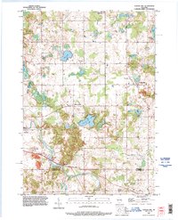 1992 School Hill1996 Print · USGSThe rural borderlands of Manitowoc and Sheboygan counties are documented here in the early nineties, showcasing a landscape shaped by glacial water and small-town roots. Genealogists can locate family landmarks such as Loreto Cemetery, School Hill, and the Salvatorian Seminary.
 - 1992 Map of Valders, 1996 Print
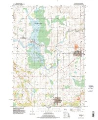 1992 Valders1996 Print · USGSManitowoc County rural life is captured here in the early nineties, centered on the villages of Valders, St Nazianz, and Collins. Genealogists and historians can trace family locations along Marken Road or locate the St Nazianz Ch and Valders Cemetery.
End of results
Showing maps 1-2 of 2
Top cities near St. Nazianz
- Sheboygan historical maps
- Manitowoc historical maps
- Town of Sheboygan historical maps
- Chilton historical maps
- New Holstein historical maps
- Kiel historical maps
See more
Top neighborhoods of St. Nazianz
Frequently asked questions
- What are the different types of historical maps available for St. Nazianz?
- What is the oldest map of St. Nazianz?
- Where can I purchase historical maps of St. Nazianz for my home or office?
- Where can I download high-res historical maps of St. Nazianz?
- Are there historical topographic maps available for St. Nazianz?
- Is there historical aerial imagery available for St. Nazianz?
- Where are historical maps of St. Nazianz sourced from?