Old Maps of Marathon County, Wisconsin for Academic Research
Study the evolution of Marathon County with 122 high-resolution historic maps. Whether you're teaching, researching, or modeling changes in land use, these maps provide essential visual documentation of urban, environmental, and geographic change.
- Analyze long-term change: Track patterns in development, transportation, and natural features.
- Ideal for environmental or urban studies: Support academic projects with primary historical map data.
- Use in the classroom or lab: Educators and researchers rely on these maps to bring historical context to life.
These maps are a powerful tool for teaching, research, and visualizing how Marathon County has changed over the decades.
Marathon County, WI maps
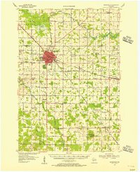
(122)- 1899 Map of Wausau, 1956 Print
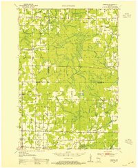
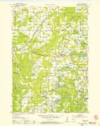
 1899 Wausau1956 Print · USGSMarathon County was a bustling timber and rail corridor at the turn of the century, anchored by the river power of Wausau and Merrill. Researchers can trace early logging lines like the Bull Dessert Logging R R and find vanished stops such as Dessert Junction and Nutterville.
 - 1902 Map of Wausau
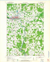
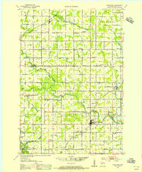
 1902 Wausau1902 Print · USGSWisconsin’s timber and rail heartland is meticulously documented at the turn of the century as Wausau and Merrill expand along the river. Genealogists can trace early homesteads and rail stops like Schofield, Granite Heights, and the grounds of the State Insane Asylum.2 unique versions available
 - 1902 Map of Marathon, 1938 Print
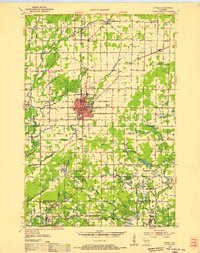
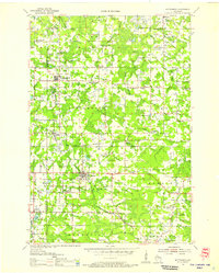
 1902 Marathon1938 Print · USGSMarathon County is captured here at the height of the timber era, when a dense network of logging railroads and new settlements defined the central Wisconsin woods. Genealogists and historians can trace early town sites like Athens, Rib Falls, and the specialized Connors Logging R. R.
 - 1951 Map of Doering, 1954 Print
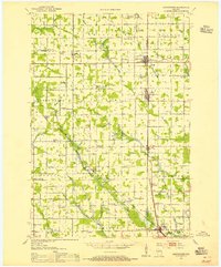
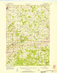
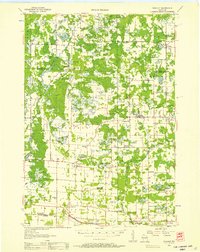
 1951 Doering1954 Print · USGSNorthwoods rural life is captured here in the early fifties across the intersection of Lincoln, Langlade, and Marathon counties. Genealogists can trace family footprints near Nutterville, Kalinke, and several country schools like Farrell Sch.2 unique versions available
 - 1951 Map of Athens, 1954 Print
 1951 Athens1954 Print · USGSMarathon and Taylor Counties are captured here in the early fifties, showing a rural landscape organized around the Soo Line railroad. Genealogists can locate dozens of country schools and churches like St Peter Ch, Goodrich Ch, and Corinth Sch.2 unique versions available
 - 1951 Map of Medford, 1954 Print
 1951 Medford1954 Print · USGSMedford and the surrounding Taylor County townships are captured here in the early fifties, showing a landscape defined by dairy farming and rail transport. Genealogists can locate numerous country schoolhouses like Thielke Sch and rural burial grounds including Little Black Cem.
 - 1951 Map of Merrill, 1954 Print
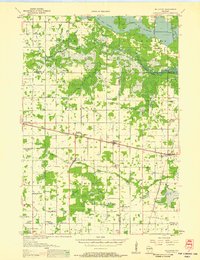
 1951 Merrill1954 Print · USGSThe Wisconsin River valley comes alive in this midcentury survey, showing the growth of Merrill and the paper mill life at Brokaw. Genealogists can trace family roots through numerous rural landmarks like Dutch Corners, St James Cem, and the Taegesville Sch.
 - 1951 Map of Hamburg, 1969 Print
 1951 Hamburg1969 Print · USGSThe rural borderlands of Lincoln and Marathon counties come alive in this mid-century survey of Wisconsin dairy country. Genealogists and historians can trace family-named sites like the Lueck Cem, Mitchell Sch, and the unique crossroads of Little Chicago.
 - 1952 Map of Antigo, 1954 Print
 1952 Antigo1954 Print · USGSAntigo and its surrounding townships are shown in detail during the early fifties, capturing a moment of transition for northern Wisconsin's rural school districts. Genealogists can locate family landmarks like the Bohemian Cem, St Johns Ch, and many local schools from Deerbrook to Mattoon.2 unique versions available
 - 1953 Map of Abbotsford, 1955 Print
 1953 Abbotsford1955 Print · USGSCentral Wisconsin dairy country in the early fifties reveals a landscape tightly organized around the rail line and township sections. Genealogists can trace family roots through numerous local landmarks like Riplinger, St Johannis Ch, and Pickard Sch.
 - 1953 Map of Wausau, 1955 Print
 1953 Wausau1955 Print · USGSThe Wisconsin River valley comes alive in the early 1950s, showing the paper-mill towns and rugged peaks of Marathon County. Trace the development of Wausau and Mosinee or locate rural landmarks like the Mosinee Lookout Tower and St Agnes Ch.
 - 1953 Map of Marathon, 1955 Print
 1953 Marathon1955 Print · USGSMarathon County's agricultural and river heartland is documented here in the early fifties, centering on the villages of Marathon and Edgar. Local historians can trace a dense network of country schools and churches like Rib Falls Ch and the St Anthony Friary.
 - 1953 Map of Hatley, 1955 Print
 1953 Hatley1955 Print · USGSMarathon County's eastern farming and timber lands are captured here in the early fifties as the rural school system began to consolidate. Genealogists can trace family footprints at St Francis Cem or follow the old Chicago and North Western rail line through Hatley.
 - 1953 Map of Stratford, 1955 Print
 1953 Stratford1955 Print · USGSMarathon County in the early fifties is captured here as a landscape of small dairy farms and rail-connected villages. Genealogists and historians can trace numerous rural landmarks, from Milan and Stratford to family-named schools like Hillcrest Sch and Wescott Sch.
 - 1953 Map of Eau Claire, 1965 Print
 1953 Eau Claire1965 Print · USGSWest-central Wisconsin in the mid-fifties shows a landscape of river-valley industry and vast wildlife refuges during the transition from rails to modern highways. Genealogists and historians can trace the rail corridors of the Chicago and North Western or locate family-named landmarks like Decorah Mound and Chippewa Island.4 unique versions available
 - 1953 Map of Rice Lake, 1967 Print
 1953 Rice Lake1967 Print · USGSNorthwest Wisconsin during the mid-fifties reveals a landscape defined by timber, rail, and water. Genealogists and historians can trace the development of river towns like Ladysmith and Rice Lake along the Soo Line and Chicago and North Western railroads.2 unique versions available
 - 1954 Map of Wittenberg, 1956 Print
 1954 Wittenberg1956 Print · USGSWisconsin’s timber and rail country is captured here during the mid-fifties as many small rural schoolhouses were being phased out. Genealogists and local historians can trace family locations near Forest Home Cem, the settlement of Regina, or the St Johannes Ch.
 - 1954 Map of Granton, 1956 Print
 1954 Granton1956 Print · USGSCentral Wisconsin's farming heartland and rural school network are preserved here during the mid-1950s. Genealogists can locate family-named landmarks and institutions like Spokeville Sch, Grace Ch, and the high ground of Lindsey Bluffs.2 unique versions available
 - 1954 Map of Marshfield, 1956 Print
 1954 Marshfield1956 Print · USGSMarshfield and the surrounding Wood County dairy lands are captured here in the mid-fifties as the city evolved into a major regional medical and rail hub. Genealogists can locate family landmarks like St Peters Ch, Trinity Cem, and dozens of rural schoolhouses including Golden Glow Sch.2 unique versions available
 - 1954 Map of Iron Mountain, 1964 Print
 1954 Iron Mountain1964 Print · USGSUpper Michigan and Northeastern Wisconsin are shown in detail during the mid-fifties, when the logging and mining economies still moved by rail. Trace the rail lines of the Soo Line to remote stops like Koepenick Station or explore the Iron Range near Iron Mountain.2 unique versions available
 - 1955 Map of Tigerton, 1957 Print
 1955 Tigerton1957 Print · USGSThe rural borderlands of Shawano and Waupaca Counties come alive in the mid-1950s, showing a landscape of small schools and river-fed mill towns. Genealogists can trace family landmarks like Alban Chapel, the Hitterdahl Ch, and old rural schoolhouses including Selmer Sch.2 unique versions available
 - 1955 Map of Rosholt, 1957 Print
 1955 Rosholt1957 Print · USGSPortage County’s rural landscape comes alive in the mid-fifties, showing the intersection of rail transport and small-town commerce. Researchers can trace family roots at St Marys Ch, locate vanished schoolhouses like Oakland Sch, or explore the rail corridor near Nelsonville.2 unique versions available
 - 1955 Map of Green Bay, 1968 Print
 1955 Green Bay1968 Print · USGSCentral and Eastern Wisconsin are captured here in the mid-fifties, showing the industrial growth of the Fox Valley and Wisconsin River corridors. Genealogists and historians can trace rail lines like the Green Bay and Western through settlements like Weyauwega, Clintonville, and Pulaski.2 unique versions available
 - 1956 Map of Milladore, 1958 Print
 1956 Milladore1958 Print · USGSIn the mid-fifties, this section of Wood County was a busy crossroads for the Soo Line and Milwaukee Road railroads. Genealogists can trace a lost network of rural education through sites like Steppingstone Sch, Lone Elm Sch, and the Runkle Sch.
 - 1956 Map of Stevens Point, 1958 Print
 1956 Stevens Point1958 Print · USGSStevens Point and the central Wisconsin River valley are captured here in the mid-fifties during a period of significant educational and infrastructure growth. Researchers can locate numerous country schools and religious landmarks, from St Francis Ch to the State Teachers College and the Cranberry Bog.2 unique versions available
Showing maps 1-25 of 122
Top cities of Marathon County
- Wausau historical maps
- Weston historical maps
- Kronenwetter historical maps
- Rib Mountain historical maps
- Rothschild historical maps
- Mosinee historical maps
See more
Frequently asked questions
- What are the different types of historical maps available for Marathon County?
- What is the oldest map of Marathon County?
- Where can I purchase historical maps of Marathon County for my home or office?
- Where can I download high-res historical maps of Marathon County?
- Are there historical topographic maps available for Marathon County?
- Is there historical aerial imagery available for Marathon County?
- Where are historical maps of Marathon County sourced from?