1960s Maps of Holton, Wisconsin
Explore 4 historic maps of Holton from the 1960s. These maps offer a rare glimpse into what life looked like during the 1960s — showing old roads, neighborhoods, homes, and landmarks that have changed or disappeared over time.
Whether you're researching your family's past, planning a metal detecting trip, or studying how Holton's landscape evolved across the 1960s, these high-resolution maps are a powerful tool for exploring the history of this region.
- Focus on a specific era: All maps on this page are from the 1960s, giving you a focused view of this time period.
- See what’s changed: Compare century-old streets, trails, and buildings to today's modern landscape using overlays and satellite layers.
- Research with precision: Use these maps for genealogy, historical research, land use analysis, or educational projects.
- View, download, or print: Maps are fully viewable online in high resolution, and can be downloaded or printed for your own records.
Start exploring Holton's history through authentic maps from the 1960s. This is your window into the past.
Holton, WI maps
(4)- 1963 Map of Stratford, 1964 Print
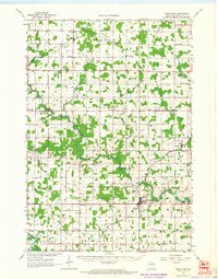 1963 Stratford1964 Print · USGSMarathon County's rural heartland is captured here in the early sixties, showing the vital intersection of rail and river commerce. Genealogists and historians can trace family locations near Stratford, March Rapids, and several country schools like Strupp Sch.
 - 1963 Map of Abbotsford, 1964 Print
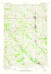 1963 Abbotsford1964 Print · USGSWisconsin's dairy heartland is mapped here in the early sixties, showing the vital junctions of the central townships. Local historians can trace family land across Unity, Beaver, and Sherman, locating landmarks like Beaver Center Sch and St Johns Cem.
 - 1964 Map of Eau Claire
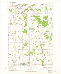
 1964 Eau Claire1964 Print · USGSWest-central Wisconsin in the mid-1960s was a hub of river-driven industry and expanding rail networks. Researchers can trace historic homesteads near Menomonie, follow the Soo Line RR through Marshfield, or explore the grounds of the Camp McCoy Military Reservation.
 - 1969 Map of Stetsonville, 1971 Print
 1969 Stetsonville1971 Print · USGSThe dairy lands of Central Wisconsin are documented here in the late sixties, showing the rural communities of Stetsonville and Dorchester along the Soo Line. Genealogists and historians can locate legacy sites like Sacred Heart Cem, Victory Sch, and the North Memorial Cem.
End of results
Showing maps 1-4 of 4
Top cities near Holton
- Medford historical maps
- McMillan historical maps
- Spencer historical maps
- Stratford historical maps
- Abbotsford historical maps
- Colby historical maps
See more
Frequently asked questions
- What are the different types of historical maps available for Holton?
- What is the oldest map of Holton?
- Where can I purchase historical maps of Holton for my home or office?
- Where can I download high-res historical maps of Holton?
- Are there historical topographic maps available for Holton?
- Is there historical aerial imagery available for Holton?
- Where are historical maps of Holton sourced from?