1960s Maps of Wien, Wisconsin
Explore 3 historic maps of Wien from the 1960s. These maps offer a rare glimpse into what life looked like during the 1960s — showing old roads, neighborhoods, homes, and landmarks that have changed or disappeared over time.
Whether you're researching your family's past, planning a metal detecting trip, or studying how Wien's landscape evolved across the 1960s, these high-resolution maps are a powerful tool for exploring the history of this region.
- Focus on a specific era: All maps on this page are from the 1960s, giving you a focused view of this time period.
- See what’s changed: Compare century-old streets, trails, and buildings to today's modern landscape using overlays and satellite layers.
- Research with precision: Use these maps for genealogy, historical research, land use analysis, or educational projects.
- View, download, or print: Maps are fully viewable online in high resolution, and can be downloaded or printed for your own records.
Start exploring Wien's history through authentic maps from the 1960s. This is your window into the past.
Wien, WI maps
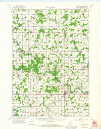
(3)- 1963 Map of Marathon, 1964 Print
 1963 Marathon1964 Print · USGSMarathon County in the early sixties is a landscape of established dairy farms and developing recreation areas. Researchers can trace the rail-side growth of Edgar and Marathon City or locate rural landmarks like Daisy Dell Sch and Sacred Heart Ch Cem.
 - 1963 Map of Stratford, 1964 Print
 1963 Stratford1964 Print · USGSMarathon County's rural heartland is captured here in the early sixties, showing the vital intersection of rail and river commerce. Genealogists and historians can trace family locations near Stratford, March Rapids, and several country schools like Strupp Sch.
 - 1964 Map of Eau Claire
 1964 Eau Claire1964 Print · USGSWest-central Wisconsin in the mid-1960s was a hub of river-driven industry and expanding rail networks. Researchers can trace historic homesteads near Menomonie, follow the Soo Line RR through Marshfield, or explore the grounds of the Camp McCoy Military Reservation.
End of results
Showing maps 1-3 of 3
Top cities near Wien
- Marshfield historical maps
- McMillan historical maps
- Stratford historical maps
- Marathon City historical maps
- Edgar historical maps
- Athens historical maps
See more
Frequently asked questions
- What are the different types of historical maps available for Wien?
- What is the oldest map of Wien?
- Where can I purchase historical maps of Wien for my home or office?
- Where can I download high-res historical maps of Wien?
- Are there historical topographic maps available for Wien?
- Is there historical aerial imagery available for Wien?
- Where are historical maps of Wien sourced from?