1980s Maps of Marquette County, Wisconsin
Explore 10 historic maps of Marquette County from the 1980s. These maps offer a rare glimpse into what life looked like during the 1980s — showing old roads, neighborhoods, homes, and landmarks that have changed or disappeared over time.
Whether you're researching your family's past, planning a metal detecting trip, or studying how Marquette County's landscape evolved across the 1980s, these high-resolution maps are a powerful tool for exploring the history of this region.
- Focus on a specific era: All maps on this page are from the 1980s, giving you a focused view of this time period.
- See what’s changed: Compare century-old streets, trails, and buildings to today's modern landscape using overlays and satellite layers.
- Research with precision: Use these maps for genealogy, historical research, land use analysis, or educational projects.
- View, download, or print: Maps are fully viewable online in high resolution, and can be downloaded or printed for your own records.
Start exploring Marquette County's history through authentic maps from the 1980s. This is your window into the past.
Marquette County, WI maps
(10)- 1980 Map of Marquette, 1981 Print
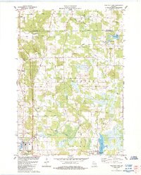
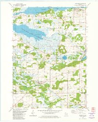 1980 Marquette1981 Print · USGSGreen Lake County at the start of the eighties shows a landscape of expansive wetlands and small railway villages. Genealogists can trace family names and local landmarks like Grand View Cem, the Salem Ch, and the Chicago and North Western rail line.
 - 1984 Map of Princeton West
 1984 Princeton West1984 Print · USGSThe Green Lake and Marquette county line comes alive in the mid-1980s as it traces the Fox River down to the shores of Puckaway Lake. Genealogists can locate family landmarks like St Johns Cem, Immanuel Ch, and the old Chicago and North Western Railroad Grade.
 - 1984 Map of Endeavor
 1984 Endeavor1984 Print · USGSThe riverine corridor of Marquette County is documented here in the mid-1980s as it transitions from the village of Endeavor into expansive wetlands. Genealogists and local historians can trace family sites at the Moundville Ch, Rood Cem, and the shores of Ennis Lake.
 - 1984 Map of Observatory Hill
 1984 Observatory Hill1984 Print · USGSMarquette and Columbia counties are captured here in the mid-1980s, where rural township life meets significant wildlife conservation lands. Researchers can trace historical footprints along the Indian Treaty Boundary or locate family sites like Log Cabin Sch and Oak Lawn Cem.
 - 1984 Map of Westfield East
 1984 Westfield East1984 Print · USGSMarquette County in the early eighties shows a landscape of winding glacial creeks and established rural villages like Westfield and Harrisville. Researchers can trace local heritage through numerous burial sites like Krentz Cem or explore the drainage of Chaffee Creek and Harris Pond.
 - 1984 Map of Neshkoro
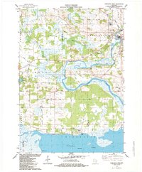
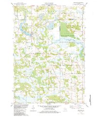 1984 Neshkoro1984 Print · USGSThe confluence of the White River and Mecan River in the mid-1980s reveals a landscape of working mills and protected wetlands. Trace local family history through sites like Bannerman, St Peter Cem, and the village of Neshkoro.
 - 1984 Map of Packwaukee
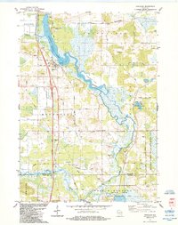
 1984 Packwaukee1984 Print · USGSMarquette County's river-and-rail landscape is captured here in the mid-1980s as the railroad still skirts the wide reach of Buffalo Lake. Local historians can trace family plots at Oak Hill Cem or locate the village of Packwaukee and the Montello Corners crossroads.
 - 1984 Map of Germania
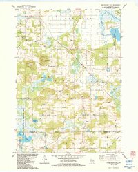
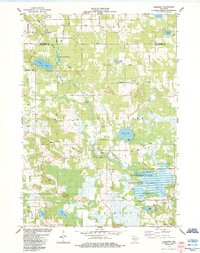 1984 Germania1984 Print · USGSThe borderlands of Marquette and Waushara Counties in the 1980s reveal a landscape of deep marshes and small rural hamlets. Local historians can trace the foundations of the community at Germania, locate the St Johns Ch Cem, and explore the wetlands of the Germania Marsh State Wildlife Area.
 - 1984 Map of Montello
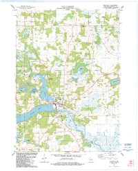 1984 Montello1984 Print · USGSMontello and the surrounding Marquette County lake country are shown here in the mid-1980s as the area balanced its agricultural roots with growing water-based recreation. Researchers can locate family landmarks like St John the Baptist Cem, Eastside Cem, and the Townhall in Shields.
 - 1985 Map of Wisconsin Dells
 1985 Wisconsin Dells1985 Print · USGSCentral Wisconsin in the mid-eighties was a landscape of intricate river bends, rail junctions, and sprawling marshlands. Researchers can trace historic routes along the Soo Line or locate family landmarks near Lyndon Station, Buffalo Lake, and Puckaway Lake.
End of results
Showing maps 1-10 of 10
Top cities of Marquette County
- Montello historical maps
- Packwaukee historical maps
- Oxford historical maps
- Endeavor historical maps
- Neshkoro historical maps
Frequently asked questions
- What are the different types of historical maps available for Marquette County?
- What is the oldest map of Marquette County?
- Where can I purchase historical maps of Marquette County for my home or office?
- Where can I download high-res historical maps of Marquette County?
- Are there historical topographic maps available for Marquette County?
- Is there historical aerial imagery available for Marquette County?
- Where are historical maps of Marquette County sourced from?