1920s Maps of Monroe County, Wisconsin
Explore 6 historic maps of Monroe County from the 1920s. These maps offer a rare glimpse into what life looked like during the 1920s — showing old roads, neighborhoods, homes, and landmarks that have changed or disappeared over time.
Whether you're researching your family's past, planning a metal detecting trip, or studying how Monroe County's landscape evolved across the 1920s, these high-resolution maps are a powerful tool for exploring the history of this region.
- Focus on a specific era: All maps on this page are from the 1920s, giving you a focused view of this time period.
- See what’s changed: Compare century-old streets, trails, and buildings to today's modern landscape using overlays and satellite layers.
- Research with precision: Use these maps for genealogy, historical research, land use analysis, or educational projects.
- View, download, or print: Maps are fully viewable online in high resolution, and can be downloaded or printed for your own records.
Start exploring Monroe County's history through authentic maps from the 1920s. This is your window into the past.
Monroe County, WI maps
(6)- 1921 Map of Kendall
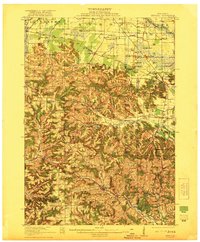 1921 Kendall1921 Print · USGSMonroe and Juneau Counties are shown here during the early twenties, where steep ridges and isolated bluffs meet productive farm valleys. Genealogists can trace family names and local landmarks like Dorset Ridge Church, Hoffman Corners, and Sugar Bowl Bluff.2 unique versions available
 - 1923 Map of Viroqua, 1960 Print
 1923 Viroqua1960 Print · USGSViroqua and the rural townships of Vernon and Monroe counties are shown in the early 1920s as a thriving network of ridge-top farms and valley schools. Genealogists can locate family landmarks like Wang Church, the Vernon County Asylum, and the Clockmaker School.
 - 1926 Map of Viroqua
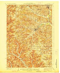
 1926 Viroqua1926 Print · USGSThe ridge-and-valley country of Vernon County is captured in the mid-1920s, showing a landscape of small farms connected by a vast network of rural schools. Genealogists can trace hundreds of family sites near Clockmaker School, Moen Church, and the Vernon County Asylum.2 unique versions available
 - 1926 Map of La Farge
 1926 La Farge1926 Print · USGSThe Kickapoo River valley in the mid-1920s reveals a landscape of ridge-top farms and isolated coulee settlements. Genealogists can trace family footprints across dozens of local school sites like Johnniecake School and through the rail corridor of the Chicago Milwaukee and St Paul River.3 unique versions available
 - 1927 Map of Hillsboro
 1927 Hillsboro1927 Print · USGSThe Driftless Area landscape near the Vernon and Sauk county lines is captured here in the mid-1920s. Genealogists can locate dozens of country schoolhouses like Whiteoak Grove School and tracing the route of the Chicago and Northeastern RR.2 unique versions available
 - 1928 Map of Melrose
 1928 Melrose1928 Print · USGSThe Black River valley in the late nineteen-twenties was a landscape of ridge-top farms and valley-floor schools. Genealogists can trace family footprints through numerous rural landmarks like Irving School No 6, Sand Creek Cem, and Wadels Hill.
End of results
Showing maps 1-6 of 6
Top cities of Monroe County
- Sparta historical maps
- Sparta historical maps
- Tomah historical maps
- Angelo historical maps
- Cashton historical maps
- Leon historical maps
See more
Frequently asked questions
- What are the different types of historical maps available for Monroe County?
- What is the oldest map of Monroe County?
- Where can I purchase historical maps of Monroe County for my home or office?
- Where can I download high-res historical maps of Monroe County?
- Are there historical topographic maps available for Monroe County?
- Is there historical aerial imagery available for Monroe County?
- Where are historical maps of Monroe County sourced from?