1970s Maps of Angelo, Wisconsin
Explore 3 historic maps of Angelo from the 1970s. These maps offer a rare glimpse into what life looked like during the 1970s — showing old roads, neighborhoods, homes, and landmarks that have changed or disappeared over time.
Whether you're researching your family's past, planning a metal detecting trip, or studying how Angelo's landscape evolved across the 1970s, these high-resolution maps are a powerful tool for exploring the history of this region.
- Focus on a specific era: All maps on this page are from the 1970s, giving you a focused view of this time period.
- See what’s changed: Compare century-old streets, trails, and buildings to today's modern landscape using overlays and satellite layers.
- Research with precision: Use these maps for genealogy, historical research, land use analysis, or educational projects.
- View, download, or print: Maps are fully viewable online in high resolution, and can be downloaded or printed for your own records.
Start exploring Angelo's history through authentic maps from the 1970s. This is your window into the past.
Angelo, WI maps
(3)- 1976 Map of La Crosse
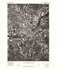
 1976 La Crosse1976 Print · USGSThe Driftless Area and Mississippi River valley are captured here in the mid-seventies, showing a landscape of deep coulees and river commerce. Genealogists can trace family footprints from La Crosse to smaller hamlets like Newburg Corners and Witoka.
 - 1976 Map of Tomah NW, 1978 Print
 1976 Tomah NW1978 Print · USGSMonroe County was undergoing significant land-use changes in the mid-1970s as agricultural fields and military lands converged. Researchers can trace the boundaries of Old Camp Mc Coy and follow the natural drainage of the La Crosse River and Silver Creek.
 - 1976 Map of Sparta NE, 1978 Print
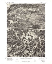
 1976 Sparta NE1978 Print · USGSMonroe County in the mid-seventies shows a landscape of growing highway corridors and traditional Wisconsin dairy farms. Trace the 1976 layout of Sparta, the smaller settlement of Angelo, and the winding path of the La Crosse River.
End of results
Showing maps 1-3 of 3
Top cities near Angelo
- Sparta historical maps
- Sparta historical maps
- Tomah historical maps
- Cashton historical maps
- Leon historical maps
- Burns historical maps
See more
Top neighborhoods of Angelo
Frequently asked questions
- What are the different types of historical maps available for Angelo?
- What is the oldest map of Angelo?
- Where can I purchase historical maps of Angelo for my home or office?
- Where can I download high-res historical maps of Angelo?
- Are there historical topographic maps available for Angelo?
- Is there historical aerial imagery available for Angelo?
- Where are historical maps of Angelo sourced from?