1980s Maps of Greenfield, Wisconsin
Explore 6 historic maps of Greenfield from the 1980s. These maps offer a rare glimpse into what life looked like during the 1980s — showing old roads, neighborhoods, homes, and landmarks that have changed or disappeared over time.
Whether you're researching your family's past, planning a metal detecting trip, or studying how Greenfield's landscape evolved across the 1980s, these high-resolution maps are a powerful tool for exploring the history of this region.
- Focus on a specific era: All maps on this page are from the 1980s, giving you a focused view of this time period.
- See what’s changed: Compare century-old streets, trails, and buildings to today's modern landscape using overlays and satellite layers.
- Research with precision: Use these maps for genealogy, historical research, land use analysis, or educational projects.
- View, download, or print: Maps are fully viewable online in high resolution, and can be downloaded or printed for your own records.
Start exploring Greenfield's history through authentic maps from the 1980s. This is your window into the past.
Greenfield, WI maps
(6)- 1983 Map of Tomah, 1984 Print
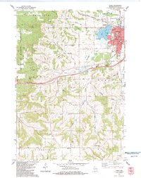 1983 Tomah1984 Print · USGSTomah and its surrounding townships are shown here in the early eighties, where the regional rail hub meets the eastern edge of the Fort McCoy Military Reservation. Genealogists and local historians can trace rural family plots at Oak Grove and St. Johns, or locate community landmarks like Jacksonville and the East Ridgeville School.
 - 1983 Map of City Rock, 1984 Print
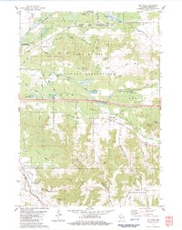 1983 City Rock1984 Print · USGSMonroe County's landscape in the early eighties shows the massive Fort Mc Coy Military Reservation alongside traditional farming valleys. Researchers can trace family history at Mound Prairie Cem and identify geologic landmarks like Chimney Rock and Jeff Davis Rock.
 - 1983 Map of Alderwood Lake, 1984 Print
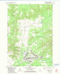 1983 Alderwood Lake1984 Print · USGSMonroe County was a blend of military training grounds and wetlands in the early eighties. You can trace the layout of Fort McCoy, locate the Lafayette Cem, or follow the C M St P & P rail line through Tarr Valley.
 - 1983 Map of Tunnel City, 1984 Print
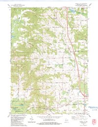 1983 Tunnel City1984 Print · USGSMonroe County's rail-and-creek landscape is captured here in the early eighties. Genealogists can trace family plots at Boyonton Cem and LaGrange Cem or locate the junction of the Chicago & NW and Milwaukee St Paul and Pacific at Tunnel City.
 - 1985 Map of Black River Falls
 1985 Black River Falls1985 Print · USGSCentral Wisconsin in the mid-1980s is defined by its sprawling wildlife refuges and the winding Black River corridor. Genealogists and researchers can trace rural settlements like Millston and Warrens or locate historical sites such as the Iron Mine and the grounds of Fort McCoy.2 unique versions available
 - 1985 Map of Sparta
 1985 Sparta1985 Print · USGSWestern Wisconsin in the 1980s shows the unique ridge-and-valley terrain of the Driftless Area during a period of transition for its rails and rural hubs. Trace the historic rail tunnels of the Elroy-Sparta State Trail and find local landmarks like St Marys Ch and Castle Rock Lake.2 unique versions available
End of results
Showing maps 1-6 of 6
Top cities near Greenfield
- Sparta historical maps
- Sparta historical maps
- Tomah historical maps
- Brockway historical maps
- Angelo historical maps
- Leon historical maps
See more
Top neighborhoods of Greenfield
Frequently asked questions
- What are the different types of historical maps available for Greenfield?
- What is the oldest map of Greenfield?
- Where can I purchase historical maps of Greenfield for my home or office?
- Where can I download high-res historical maps of Greenfield?
- Are there historical topographic maps available for Greenfield?
- Is there historical aerial imagery available for Greenfield?
- Where are historical maps of Greenfield sourced from?