1980s Maps of Jefferson, Wisconsin
Explore 5 historic maps of Jefferson from the 1980s. These maps offer a rare glimpse into what life looked like during the 1980s — showing old roads, neighborhoods, homes, and landmarks that have changed or disappeared over time.
Whether you're researching your family's past, planning a metal detecting trip, or studying how Jefferson's landscape evolved across the 1980s, these high-resolution maps are a powerful tool for exploring the history of this region.
- Focus on a specific era: All maps on this page are from the 1980s, giving you a focused view of this time period.
- See what’s changed: Compare century-old streets, trails, and buildings to today's modern landscape using overlays and satellite layers.
- Research with precision: Use these maps for genealogy, historical research, land use analysis, or educational projects.
- View, download, or print: Maps are fully viewable online in high resolution, and can be downloaded or printed for your own records.
Start exploring Jefferson's history through authentic maps from the 1980s. This is your window into the past.
Jefferson, WI maps
(5)- 1983 Map of Westby
 1983 Westby1983 Print · USGSThe ridge-and-valley country of Vernon and Monroe counties is captured here in the early eighties. Genealogists can trace family lines at Coon Prairie Ch and Pleasant View Cem, or locate landmarks like the Ski Jumps and Living Waters Camp.2 unique versions available
 - 1983 Map of St. Marys, 1984 Print
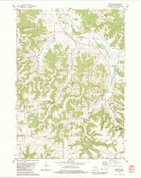
 1983 St. Marys1984 Print · USGSMonroe County was a landscape of ridgeline cemeteries and deep valley farms in the early 1980s. You can trace family roots at Summit Ridge Cem and St Jacobs Cem, or follow the historic rail corridor now designated as the Elroy Sparta State Trail.
 - 1983 Map of Dell, 1984 Print
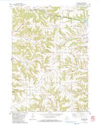
 1983 Dell1984 Print · USGSVernon County and the Driftless Area topography are captured here in the early eighties. Genealogists can locate family-named landmarks like Potts Corners or trace rural community centers including Sugar Grove Ch and the Bad Axe Cem.
 - 1983 Map of Melvina, 1984 Print
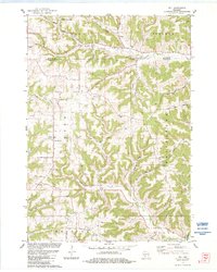
 1983 Melvina1984 Print · USGSThe Driftless Area of Monroe County is shown in the early 1980s, shaped by the Little La Crosse River and the winding rail lines of the era. Genealogists and historians can locate the Union Cem, the settlement of Portland, and the old Chicago and North Western railroad grade.
 - 1985 Map of Sparta
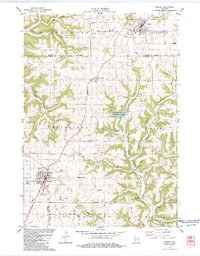
 1985 Sparta1985 Print · USGSWestern Wisconsin in the 1980s shows the unique ridge-and-valley terrain of the Driftless Area during a period of transition for its rails and rural hubs. Trace the historic rail tunnels of the Elroy-Sparta State Trail and find local landmarks like St Marys Ch and Castle Rock Lake.2 unique versions available
End of results
Showing maps 1-5 of 5
Top cities near Jefferson
- Sparta historical maps
- Sparta historical maps
- Tomah historical maps
- Viroqua historical maps
- Westby historical maps
- Angelo historical maps
See more
Top neighborhoods of Jefferson
Frequently asked questions
- What are the different types of historical maps available for Jefferson?
- What is the oldest map of Jefferson?
- Where can I purchase historical maps of Jefferson for my home or office?
- Where can I download high-res historical maps of Jefferson?
- Are there historical topographic maps available for Jefferson?
- Is there historical aerial imagery available for Jefferson?
- Where are historical maps of Jefferson sourced from?