1970s Maps of Brazeau, Wisconsin
Explore 5 historic maps of Brazeau from the 1970s. These maps offer a rare glimpse into what life looked like during the 1970s — showing old roads, neighborhoods, homes, and landmarks that have changed or disappeared over time.
Whether you're researching your family's past, planning a metal detecting trip, or studying how Brazeau's landscape evolved across the 1970s, these high-resolution maps are a powerful tool for exploring the history of this region.
- Focus on a specific era: All maps on this page are from the 1970s, giving you a focused view of this time period.
- See what’s changed: Compare century-old streets, trails, and buildings to today's modern landscape using overlays and satellite layers.
- Research with precision: Use these maps for genealogy, historical research, land use analysis, or educational projects.
- View, download, or print: Maps are fully viewable online in high resolution, and can be downloaded or printed for your own records.
Start exploring Brazeau's history through authentic maps from the 1970s. This is your window into the past.
Brazeau, WI maps
(5)- 1973 Map of Kelly Lake, 1977 Print
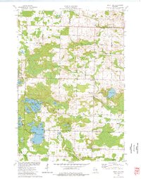 1973 Kelly Lake1977 Print · USGSThe glacial lake country of Oconto County is captured here in the early seventies, showing a landscape defined by water and woods. Genealogists can locate family landmarks like Section Eight Church, St Wenceslaus Cem, and the old Klondike settlement.
 - 1973 Map of Hickory Corners, 1977 Print
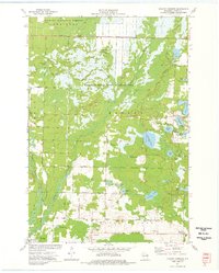 1973 Hickory Corners1977 Print · USGSOconto County in the early seventies reveals a landscape of dense wetlands and forest edge settlements. Genealogists and historians can trace family locations near Hickory Corners, Frostville, and the Hickory Cem, or locate landmarks like the Bagley Lookout Tower.
 - 1973 Map of Shay Lake, 1977 Print
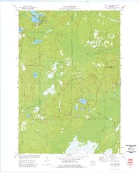 1973 Shay Lake1977 Print · USGSThe Northwoods of Oconto County are shown here in the 1970s, revealing a landscape defined by timber, glacial lakes, and the Nicolet National Forest. Researchers can trace old logging routes and rural landmarks like Butler Rock, St Marys of the Lake Ch, and the remote Landing Strip.
 - 1973 Map of Coleman, 1977 Print
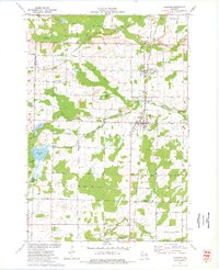 1973 Coleman1977 Print · USGSThe villages of Pound and Coleman are shown during the 1970s as vital hubs along the Chicago Milwaukee St Paul and Pacific railroad. Genealogists and local historians can trace family sites at St Leos Cem, Town Cem, and the rural Section Eight Sch.
 - 1973 Map of White Potato Lake, 1977 Print
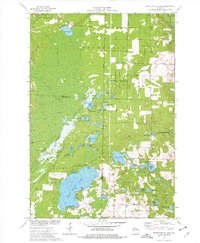 1973 White Potato Lake1977 Print · USGSThe Marinette County lake country is captured here in the early seventies, just as modern conservation efforts were shaping the land. Genealogists and historians can locate Brazeau Cem, the Patz Landing Field, and the many family-named waters like Heisel Lake.
End of results
Showing maps 1-5 of 5
Top cities near Brazeau
- Oconto Falls historical maps
- Stiles historical maps
- Gillett historical maps
- Beaver historical maps
- Crivitz historical maps
- Spruce historical maps
See more
Top neighborhoods of Brazeau
Frequently asked questions
- What are the different types of historical maps available for Brazeau?
- What is the oldest map of Brazeau?
- Where can I purchase historical maps of Brazeau for my home or office?
- Where can I download high-res historical maps of Brazeau?
- Are there historical topographic maps available for Brazeau?
- Is there historical aerial imagery available for Brazeau?
- Where are historical maps of Brazeau sourced from?