1900s (20th Century) Maps of Breed, Wisconsin
Explore 7 historic maps of Breed from the 1900s (20th Century). These maps offer a rare glimpse into what life looked like during the 1900s — showing old roads, neighborhoods, homes, and landmarks that have changed or disappeared over time.
Whether you're researching your family's past, planning a metal detecting trip, or studying how Breed's landscape evolved across the 1900s, these high-resolution maps are a powerful tool for exploring the history of this region.
- Focus on a specific era: All maps on this page are from the 1900s, giving you a focused view of this time period.
- See what’s changed: Compare century-old streets, trails, and buildings to today's modern landscape using overlays and satellite layers.
- Research with precision: Use these maps for genealogy, historical research, land use analysis, or educational projects.
- View, download, or print: Maps are fully viewable online in high resolution, and can be downloaded or printed for your own records.
Start exploring Breed's history through authentic maps from the 1900s. This is your window into the past.
Breed, WI maps
(7)- 1942 Map of Breed
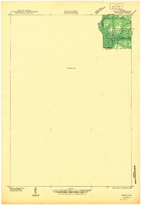 1942 Breed1942 Print · USGSMarinette and Oconto counties appear here in the early 1940s, showing a mix of established survey lines and wilder interior lands. Local researchers can trace the early courses of Peshtigo Brook and the West Branch through the township of Stephenson.
 - 1952 Map of Mountain, 1955 Print
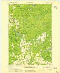 1952 Mountain1955 Print · USGSOconto County in the early fifties shows a patchwork of timberland and early farmsteads connected by the North Western railroad. Trace family sites at Breed and Frostville, or locate rural landmarks like the Breed Cemetery and Mountain Lookout Tower.2 unique versions available
 - 1954 Map of Iron Mountain, 1964 Print
 1954 Iron Mountain1964 Print · USGSUpper Michigan and Northeastern Wisconsin are shown in detail during the mid-fifties, when the logging and mining economies still moved by rail. Trace the rail lines of the Soo Line to remote stops like Koepenick Station or explore the Iron Range near Iron Mountain.2 unique versions available
 - 1959 Map of Iron Mountain
 1959 Iron Mountain1959 Print · USGSThe northwoods of Wisconsin and the Michigan border are captured here in the mid-fifties, showing a landscape defined by timber, water, and rail. Researchers can trace historic junctions like Hiles Junction, the expansive Nicolet National Forest, and lakefront settlements from Rhinelander to Tomahawk.2 unique versions available
 - 1973 Map of Hickory Corners, 1977 Print
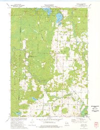
 1973 Hickory Corners1977 Print · USGSOconto County in the early seventies reveals a landscape of dense wetlands and forest edge settlements. Genealogists and historians can trace family locations near Hickory Corners, Frostville, and the Hickory Cem, or locate landmarks like the Bagley Lookout Tower.
 - 1973 Map of Breed, 1977 Print
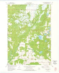
 1973 Breed1977 Print · USGSThe Oconto County woodlands were a landscape of managed forests and river wildlife areas in the early 1970s. Local researchers can trace family landmarks and rural infrastructure from the Menominee Indian Reservation to the Union Cem and Piso Landing Strip.
 - 1990 Map of Wabeno, 1991 Print
 1990 Wabeno1991 Print · USGSThe Wisconsin Northwoods in the early nineties is a landscape of deep timber, tribal lands, and glacial lakes. Researchers can trace the Chicago and North Western rail line through lumber towns like Wabeno and Townsend or locate the Lakewood State Fish Hatchery.
End of results
Showing maps 1-7 of 7
Top cities near Breed
- Keshena historical maps
- Gillett historical maps
- Green Valley historical maps
- Townsend historical maps
- Morgan historical maps
- Spruce historical maps
See more
Top neighborhoods of Breed
Frequently asked questions
- What are the different types of historical maps available for Breed?
- What is the oldest map of Breed?
- Where can I purchase historical maps of Breed for my home or office?
- Where can I download high-res historical maps of Breed?
- Are there historical topographic maps available for Breed?
- Is there historical aerial imagery available for Breed?
- Where are historical maps of Breed sourced from?