1960s Maps of Ellington, Wisconsin
Explore 2 historic maps of Ellington from the 1960s. These maps offer a rare glimpse into what life looked like during the 1960s — showing old roads, neighborhoods, homes, and landmarks that have changed or disappeared over time.
Whether you're researching your family's past, planning a metal detecting trip, or studying how Ellington's landscape evolved across the 1960s, these high-resolution maps are a powerful tool for exploring the history of this region.
- Focus on a specific era: All maps on this page are from the 1960s, giving you a focused view of this time period.
- See what’s changed: Compare century-old streets, trails, and buildings to today's modern landscape using overlays and satellite layers.
- Research with precision: Use these maps for genealogy, historical research, land use analysis, or educational projects.
- View, download, or print: Maps are fully viewable online in high resolution, and can be downloaded or printed for your own records.
Start exploring Ellington's history through authentic maps from the 1960s. This is your window into the past.
Ellington, WI maps
(2)- 1969 Map of Greenville, 1972 Print
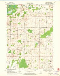 1969 Greenville1972 Print · USGSOutagamie County is documented here in the late sixties as the local infrastructure of Greenville and Hortonville expanded. Researchers can trace historic family burial sites at Wanderers Rest Cem, find the Wide Awake Sch, and follow the CHICAGO AND NORTH WESTERN rail line.2 unique versions available
 - 1969 Map of Shiocton, 1972 Print
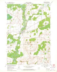 1969 Shiocton1972 Print · USGSWisconsin's Fox Valley region in the late sixties reveals a landscape shaped by the winding Wolf River and the Green Bay and Western railroad. Genealogists and local historians can trace family connections at Bovina Cem or locate old homesteads along Mayflower Drive and Kirschner Road.2 unique versions available
End of results
Showing maps 1-2 of 2
Top cities near Ellington
- Appleton historical maps
- Neenah historical maps
- Grand Chute historical maps
- Fox Crossing historical maps
- Menasha historical maps
- Little Chute historical maps
See more
Top neighborhoods of Ellington
Frequently asked questions
- What are the different types of historical maps available for Ellington?
- What is the oldest map of Ellington?
- Where can I purchase historical maps of Ellington for my home or office?
- Where can I download high-res historical maps of Ellington?
- Are there historical topographic maps available for Ellington?
- Is there historical aerial imagery available for Ellington?
- Where are historical maps of Ellington sourced from?